Le Moule - Bois Baron trail
Le Moule North Grande-Terre circular trail
 Coastal trail
Le Moule - Bois Baron trail
Medium
3h
8,4km
+176m
-176m
Loop
PR (short hike network)
Embed this item to access it offline
12 points of interest
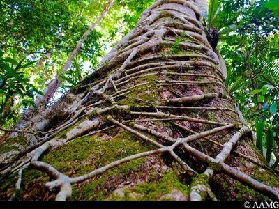
AAMG  Flora
Flora"Giant bearded fig"
The seeds of these trees are often carried by birds and sprout in the upper branches of a host tree and develop as epiphytes. They then form aerial roots growing down towards the ground, as well as branches growing upwards to capture more sunlight. When the aerial roots reach the ground, the fig tree starts to grow more quickly. The aerial roots join together as they grow, until they form a trellis that is thick enough for the tree to stand on its own. So it no longer needs the tree on which it developed. This trellis may end up preventing the support tree from growing widthways, thus causing it to die (if the fig tree grows on a tree that does not grow widthways, especially palm trees, then the host tree can continue to live with the fig tree around it for a long time).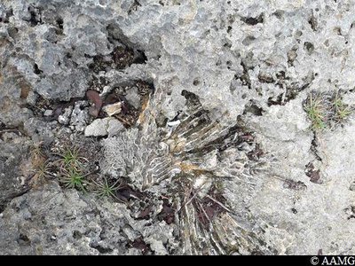
AAMG  Geology
The cay
The island of Grande-Terre is made up of limestone rocks from sedimentation that began 5 million years ago and ended 400,000 years ago, when the island emerged from the waters. Sedimentary rock is made up of animal remains, and in several places in the rock you can see traces of ancient underwater life in the form of fossils.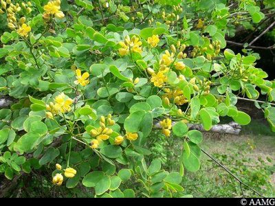
AAMG FloraRambling senna
Rambling senna (Senna bicapsularis), also known as soumaké and kaka béké in Creole, is a small bush with alternating, smooth and circular leaves and yellow clusters of flowers. It is a medicinal plant with properties for treating skin disease and constipation (mild laxative).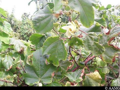
AAMG FloraLevant cotton
Levant cotton (Gossypium herbaceum) is a woody shrub growing from 1m to 1m 50. It is native to India and the Arabian peninsula, and likes heat and sunshine. Its blossom looks like hibiscus flowers. The blossom is yellow, but turns pink when the plant is older. The centre has purplish blue areas. The blossom then turns into capsules (fruit) containing 20 to 50 black seeds, each surrounded by thousands of long, white fibres: cotton.
Cotton was first used by native Americans and was one of the products exported from early colonial times, like pétun (tobacco) or indigo.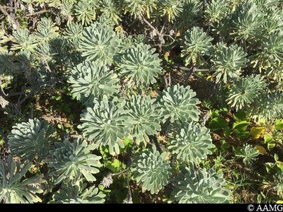
AAMG Flora"Pride of big pine"
Providing a real floral parade in coastal and sandy areas, this round bush (1m) has silvery leaves and plentiful branches. Its leaves are covered in down. They are simple, without stalks and grouped together at the tips. The little white flowers grow in clusters. Not to be confused with bay cedar (Suriana maritima).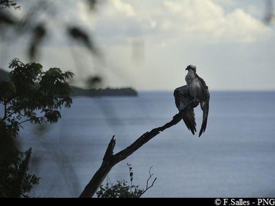
PNG  Fauna
FaunaWestern osprey
The western osprey (Pandion haliaetus) is a large bird of prey with a wingspan reaching up to 1m80 and weighing 1.5 kg. This predator only eats fish. Its fishing technique is spectacular. It flies between 10 to 50 metres above the water, spots its prey, soars downwards by folding its wings, then redeploys them before the impact and moves its talons in front of it. It captures fish weighing 500g or more... up to 1.5 kg its own weight! Some birds often come to Guadeloupe from September to March. They reproduce in North America (Canada). In the less favourable season (autumn / winter), they go to South America or spend the winter in the West Indies. A few younger individuals (aged 3 to 5) may even spend all the year in Guadeloupe.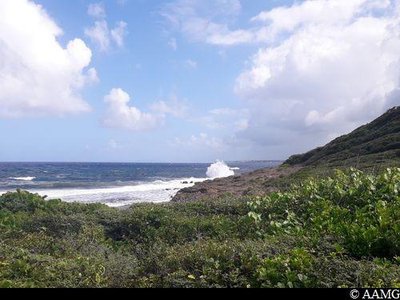
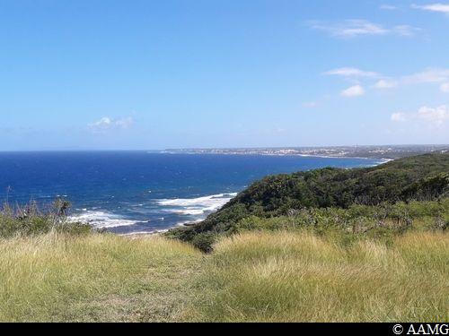
AAMG  Viewpoint
Panorama
View over the coast in Anse Patate.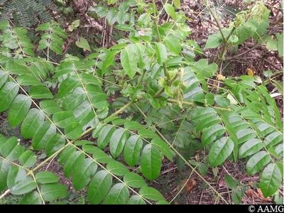
AAMG FloraCaesalpinia bonduc
This is a prickly bush with alternating leaves made up of 5 to 7 pairs of oval leaflets. It has yellow flowers in clusters. Its fruits have seeds in pods. The seeds are much in demand to make necklaces. This is an astringent plant that is believed to be an antidote for poison.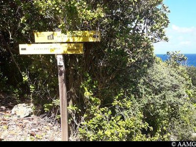
AAMG  Information board
Signpost
Intersection with the route of the coastal trail towards L'Anse Maurice (north).
[For the Bois Baron trail, turn left and go up towards the road]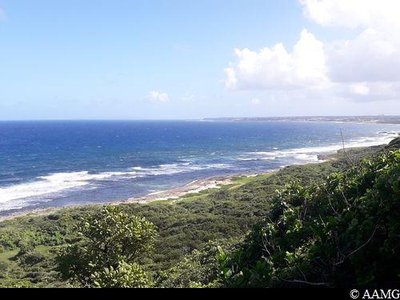
AAMG ViewpointBois Baron cliff viewpoint
A great view over the Bois Baron cliff.
AAMG ViewpointParagliding panorama
The jump-off point for paragliders. The wind conditions and the natural slope of the land are ideal. From the Bois Baron site, paragliders can fly about 8 km to the north, towards Anse Marguerite and Anse Maurice. Or about 3 km south towards the Edgar Clerc Museum. Flights take place mainly between the slope and the coast or above the sea. Before take off, a gentle slope leads to a flat area near the sea, where it is easy to land. This is also the case further south, where it is possible to land practically all along the way.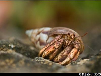
PNG FaunaCaribbean hermit crab
The Caribbean hermit crab (Coenobita clypeatus), known as "Souda" in Creole, lives on beaches and in mangrove forests. The crabs like tropical coastal areas with plenty of humidity and warmth, as well as forest areas at the edge of the beach. Their biotope varies with age, so you can find adults several miles inland and at an altitude of up to one hundred metres. Hermit crabs are active at night. During the day, they hide under leaves, in holes or woody debris, or in projecting rock. They are excellent climbers and can be found at the summit of coastal trees. They are omnivorous and detritivores, feeding on plants or dead animals, and even the excrement of other animals, as well as fruit, seeds, shore waste, birds eggs and turtles eggs, animal carcasses, etc.
Description
Cross the beach, then the bridge. Follow the path just after the bridge to the right. Walk along the coast, then turn slightly to the left. The path goes past some houses (garden). Turn right towards the sea. Continue the path along the coast, following the markings on the ground over the rocky areas or on the trees in wooded areas.
After Anse Patate continue to the right at the intersection. Walk along the coast, then turn left to take the steep slope leading up to the paragliding site.
During the climb, make sure you go towards the left. Don't turn right at the intersection towards Anse Maurice.
At the road, turn left, passing by the car park and the paragliders' area. Follow the path that goes downwards, and then you will reach the coastal path you took on the way up.
- Departure : L'Anse la Baie car park, Le Moule
- Arrival : L'Anse la Baie car park, Le Moule
- Towns crossed : Le Moule
Altimetric profile
Recommandations
In this natural setting, you should be particularly careful and alert, since Guadeloupe is subject to natural risks. It is vital to act in a responsible way, so that everyone can enjoy the hike!
Please note: unsupervised car parks.
Please note: unsupervised car parks.
Information desks

2 rue Gambetta, 97117 Port-Louis
Access and parking
GPS starting point: Lat: 16,33504° N - Long: 61,36864° W.
---
Arriving from Pointe à Pitre / Abymes: follow the N5 road to Morne-à-l'Eau, then head for Le Moule.
After the intersection with the D123 towards Sainte Marguerite and the Musée Edgard Claire, continue straight on until the bridge. Park at the Anse La Baie car park to the left, just after the bridge.
Arriving from Saint-François: follow the RN road towards Le Moule; cross the town and continue towards La Baie.
Parking :
Car park at Anse la Baie beach, Le Moule.
Source
Rando Guadeloupehttps://www.randoguadeloupe.gp/
Report a problem or an error
If you have found an error on this page or if you have noticed any problems during your hike, please report them to us here: