Houëlmont educational trail
Gourbeyre
Houëlmont educational trail
Very easy
2h
987m
+62m
-63m
Loop
PR (short hike network)
Embed this item to access it offline
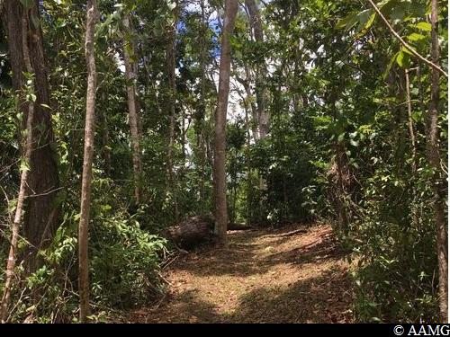
Historic remains, endemic fauna and flora of Guadeloupe all feature in the trail.
4 points of interest
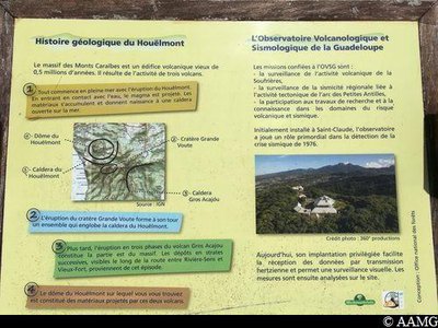
panneau - AAMG  Geology
The Houëlmont geological history
The Houëlmont dome, the scene for this trail, is made up of materials, stone blocks and ash emitted by two nearby eruptions of the "Grande Voûte" crater and the "Gros Acajou" volcano.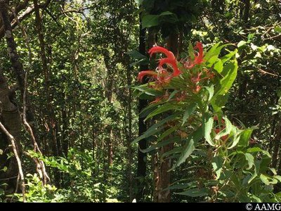
Herbe poison - AAMG  Flora
FloraHerbe poison
Herbe poison (Lobelia Persicifolia), literally "poison grass", is endemic to Guadeloupe and found nowhere else. It is relatively widespread in both the mesophile forest (with average humidity) and hygrophile or rain forest.
It is thought to have been used by native Americans to intoxicate fish, making it easier to catch them.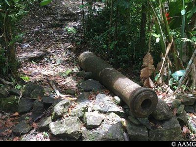
canon - AAMG  History
Houëlmont artillery battery
Here we can see the remains of the foundations and a cannon from an artillery battery.
The south of Basse-Terre is richly endowed in these remains. The fort was once used to defend the island against invasion.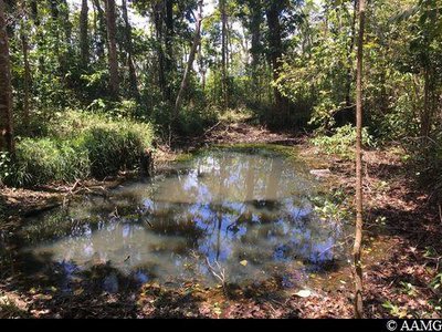
AAMG  Pond
PondHouëlmont pond
Houëlmont pond is unusual in being suspended, as it were, between two slopes. It is on a narrow sloping ledge in a surprising position. It is a source of life for local fauna: many dragonflies come here to reproduce and there are also small fish.
Description
You start off by going through the gate at the side of the barrier. A National Forests Office sign shows the entrance. The way is quite straightforward along a path with clear, yellow markings. Be careful in wet weather, the path can get slippery. A few steps have been added to make progress easier.
NB: the ONF has produced the "Sylvascope" for the educational trail. This is a tablet guide introducing you to the forest with a quiz about the environment. The terminals along the way correspond to guide stations. Pick up the tablet from the ONF Sylvathèque in Gourbeyre before setting off on the hike (0590 81 37 57 or 0590 99 28 99). You can also download the Sylvascope app from the Google Play and Apple stores.
NB: the ONF has produced the "Sylvascope" for the educational trail. This is a tablet guide introducing you to the forest with a quiz about the environment. The terminals along the way correspond to guide stations. Pick up the tablet from the ONF Sylvathèque in Gourbeyre before setting off on the hike (0590 81 37 57 or 0590 99 28 99). You can also download the Sylvascope app from the Google Play and Apple stores.
- Departure : Volcanological Observatory, Houëlmont, Gourbeyre.
- Arrival : Volcanological Observatory, Houëlmont, Gourbeyre.
- Towns crossed : Gourbeyre
Altimetric profile
Recommandations
Don't forget a good pair of walking shoes, a walking pole for those who need help in keeping their balance and for the climbs, a fully charged mobile phone and some water.
In this natural setting, you should be particularly careful and alert, since Guadeloupe is subject to natural risks. It is vital to act in a responsible way, so that everyone can enjoy the hike!
Please note: unsupervised car park.
In this natural setting, you should be particularly careful and alert, since Guadeloupe is subject to natural risks. It is vital to act in a responsible way, so that everyone can enjoy the hike!
Please note: unsupervised car park.
Information desks

46 rue Paul Baudot, 97100 Basse-Terre

rond point "Dos d'Ane", Valkanaërs, 97113 Gourbeyre
Transport
No public transport. A car is essential.
Access and parking
GPS starting point: 15,98045° N - Long: 61,70375° W.
---
Arriving from the N1 road, in Gourbeyre, head for Blanchet, Bisdary. Follow the signs to the Vocanological Observatory. Go up to the top of the morne (hill) along the concrete road.
---
Arriving from the N1 road, in Gourbeyre, head for Blanchet, Bisdary. Follow the signs to the Vocanological Observatory. Go up to the top of the morne (hill) along the concrete road.
Parking :
Park your car just next to the Vocanological centre fence.
More information
Source
Rando Guadeloupehttps://www.randoguadeloupe.gp/
Report a problem or an error
If you have found an error on this page or if you have noticed any problems during your hike, please report them to us here: