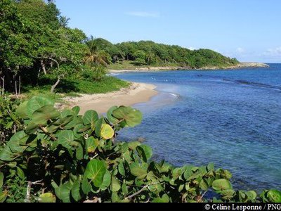
Sainte-Rose coastline
Maurice Valy, park warden at the Guadeloupe National Park, shares some linguistic trivia with us. He is from the north of Basse Terre, where the Anona glabra was traditionally called "Cachiman à chien" (custard apple of the dog) and not "Cachiman cochon" (custard apple of the pig).
10 points of interest
le littoral à Anse Vinty - Céline Lesponne / PNG  Viewpoint
Anse Vinty
At the outlet of l'Anse Vinty, splendid views of le Grand-Cul-de-Sac Marin.
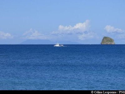
vue sur l'îlet Tête-à-l'Anglais - Céline Lesponne / PNG ViewpointViews of le Grand-Cul-de-Sac Marin
From Pointe Nogent, views of le Grand-Cul-de-Sac Marin and l'îlet Tête-à-l'Anglais.
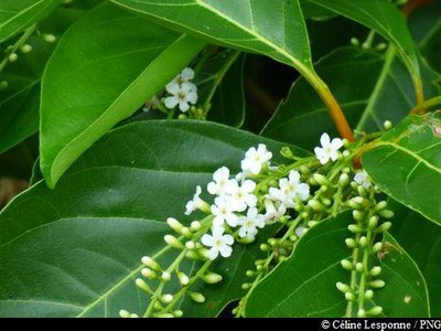
"Liane barrique" - Céline Lesponne / PNG  Flora
FloraDalbergia ecastaphyllum
A lianescent shrub with long, flexible branches, Dalbergia ecastaphyllum has alternating and pointed leaves. It boasts fragrant white flowers, with round, flattened fruits in pods that enclose a single seed. The branches of this shrub were once used to tie up barrels.
"Bois enivrant" - Céline Lesponne / PNG FloraPiscidia carthagenesis
Piscidia carthaganensis has numerous medicinal properties: it is reported to be hypnotic, analgesic and anti-spasmodic.
This plant was used by fisherman to intoxicate river fish, making it easier to catch them.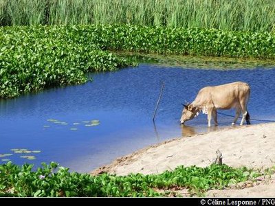
Zone humide de Nogent - Céline Lesponne / PNG  Pond
PondWetland area of l'Anse du Petit Fort
The mouth of a small river at the beach forms a specific ecosystem : a coastal wetland area. The flora here is often typified by Antelope grass (Echinochloa pyramidalis), sedge marshes (Rhynchospora corymbosa) and a woody species: Icaco (Chrysobalanus icaco). The marsh serves as a water reservoir for livestock.
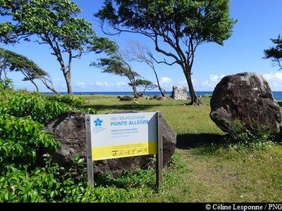
site de la Pointe Allègre - Céline Lesponne / PNG  History
Pointe Allègre
It was at Pointe Allère that the first French settlers arrived in 1635. Under the stewardship of captains Du Plessis and L'Olive, and with 400 committed men and four Dominican priests in tow, the travellers set out to establish a colony on the island, which had previously been inhabited by Carib Indians. Stricken by terrible hunger, most of the settlers were wiped out. The survivors decided to head south to Basse Terre, leaving behind but a few men who went on to found the parish of Sainte-Rose. Today, the site is still steeped in the cultural and historical significance of those events.
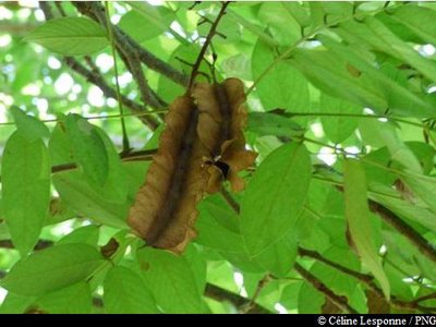
"Cachiman cochon" en saison sèche - Céline Lesponne / PNG FloraAnnona glabra
Annona glabra is also commonly known as the Swamp apple. A member of the Annonaceae family, this small tree thrives in the swampy areas of the Caribbean. Although it is not eaten very often in Guadeloupe, the fruit has a pleasant fragrance and yields a creamy juice (N.B. If you want to make the juice, do not grind the seeds as they have insecticidal qualities). This tree is also renowned for its medicinal values: the leaves are anti-diarrheal, for example. The tree's spongy roots were used by fishermen as floats for their nets. The tree was also used to make the peak of the salako hat, which was worn on Les Saintes.
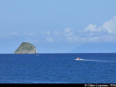
Tête-à-l'Anglais et Montserrat au loin - Céline Lesponne / PNG ViewpointIslets
From la Pointe des Iles, beautiful views of the Kahouanne and Tête-à-l'Anglais islets, in the bay of Grand-Cul-de-Sac Marin.
Fleurs du Bois carré - Céline Lesponne / PNG FloraSpiny fiddlewood
A typical tree of the Guadeloupe dry forest, Spiny fiddlewood (Citharexylum spinosum) can grow up to 15 metres tall. It can be identified by the orange petioles on its leaves and by its small, orange-black round fruits arranged in clusters. Its flowers are white, fragrant and honey-producing.
Tamarinier et fruits - Céline Lesponne / PNG FloraTamarind
Tamarind (Tamarindus indica) belongs to the Fabaceae family. Its fruits are brown and pod-like which resemble a bean in their shape. Inside, the seeds are covered in a pulp: a delicious, tangy flesh. The fruit is consumed locally in the form of a juice and fruit paste.
Description
Hiking trail colour : yellow
Signs : Coastal Conservatory.
At the bottom of the parking area of the Amandiera beach (western side), start out on the marked path which leads into the forest. Come out onto l'Anse Vinty and then keep going along the coast until La Pointe Nogent. Continue along the back shore of l'Anse Nogent and then alongside the beach until you reach la Pointe Allègre. Keep going along the coast, past l'Anse des Iles. Once you get to the parking area, go past the traditional carbet huts and then go down until you are alongside the Cluny beach and continue the hike from there. Keep going on the beach, go past the picnic carbets and cross the large parking area (shower available).
Then take the small track between the trees and walk until you reach the restaurant and the signs marking the start of the trail.
N.B. As this is a circular trail, make sure you leave your vehicle at the start point.
- Departure : Sainte-Rose, Amandiers beach.
- Arrival : Sainte-Rose, Cluny beach.
- Towns crossed : Sainte-Rose
Altimetric profile
Recommandations
As Guadeloupe is prone to natural risks, extra care should be taken in this natural environment. For the benefit of all hikers, responsible behaviour is very important.
Please note: the parking and swimming areas are not supervised.
The northern Basse Terre coastline includes some nesting sites for sea turtles. Please treat the beaches with due consideration !
Information desks

Place tricolore, 97115 Sainte-Rose
le bourg, 97126 Deshaies
Access and parking
GPS coordinates of the start point : Lat : 16,35188 N - Long : 61,72498 W.
At Sainte-Rose, on Route RN2, between the sections "Nogent" and "Comté" (known as "Madame"): turn towards the Amandiers beach.
Park at the large car park on the seafront.
Parking :
More information
Source
Report a problem or an error
If you have found an error on this page or if you have noticed any problems during your hike, please report them to us here: