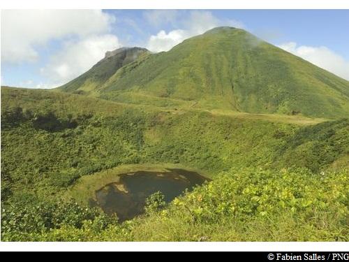
Galion / Armistice circuit
Attachment
- Downloadpdf
Les sources hydrothermales du massif de la Soufriere
Credit: fiche pédagogique BRGM au sujet des sources hydrothermales du massif de la Soufriere - BRGM
17 points of interest
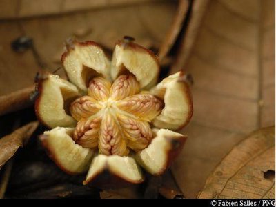
Figuier - Fabien Salles / PNG  Flora
FloraShortleaf fig
The shortleaf fig tree (Ficus citrifolia) is a member of the Moraceae family. It is quite a unique tree: as an epiphyte, it has the ability to grow on competing trees. Its aerial roots develop by dropping downwards and then branching out as the tree grows. It can strangle competing trees and kill them.
The shortleaf fig can grow both on the ground and on buildings.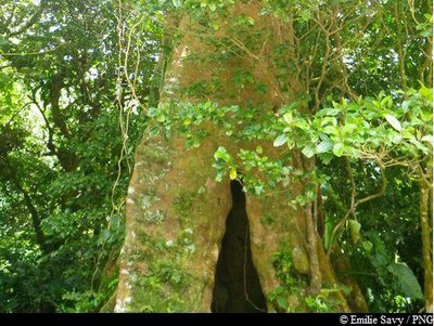
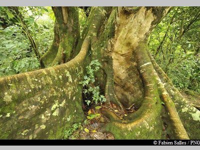
Acomat Boucan - Emilie Savy / PNG FloraAcomat boucan
The Acomat boucan (Sloanea caribaea) belongs to the Elaeocarpaceae family. It is an extremely large tree that can grow up to 40 metres tall. It is the most spectacular tree in the Sloanea genus. It has an exposed trunk and magnificent buttresses, with reddish-brown bark that starts to peel off into thin strips when the tree starts to age.
Formerly, visitors to the forest would make use of its enormous buttresses to shelter their fires and to smoke meat. It has since been established that lighting fires among the roots is not conducive to the well-being of trees.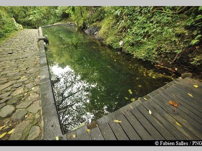
le bassin des Bains Jaunes - Fabien Salles / PNG  Area of relaxation
Les Bains Jaunes
Set amid the forest of the same name, the site of Les Bains Jaunes has long been a popular destination. The first dwellings here were the ajoupa of the Igneri people, followed by mouina of the Carib Indians.
Many years later, it became an important stopping-off point on the road to La Soufrière. In the late nineteenth century, the soldiers from Saint-Claude built a convalescent home and shooting range. Around 1910, the famous Mountaineers Club erected a makeshift shelter and later, in 1947, the Renaissance association built their own shelter, designed for hikers and swimmers. That building was later to become the Maison du Volcan, which has since closed. It is thanks to the soldiers of the Marine Infantry, who were sent to Bains Jaunes in order to "acclimatise themselves", that a stone lagoon - still in place today - was built in 1887.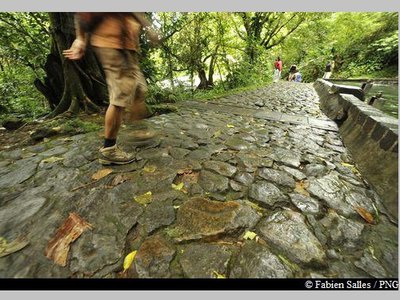
sentier du Pas du Roy - Fabien Salles / PNG  History
Le Pas du Roy
"Lest we forget that we owe the current path of Le Pas du Roy to the battalion commander, Mr. Legot. He replaced the old path that was originally mapped out by Mr. Rollin in January 1885 to guide the Count and Countess of Bardy to La Soufrière." Gérard Werter, "Coureur des Bois".
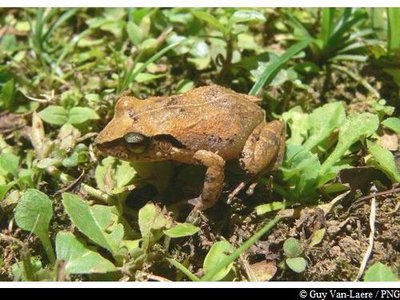
Hylode de la Martinique - Guy Van-Laere / PNG  Fauna
FaunaThe frogs of Guadeloupe
There are two endemic species of frog in Basse-Terre: Hylode de Barlagne (Eleutherodactylus barlagnei) and Hylode de Pinchon (Eleutherodactylus pinchoni), and if you listen carefully you might just hear them ribbiting at Pas du Roy. Both species are dark in colour and measure 2-3 centimetres in length. But, the most common species in Guadeloupe is the Martinique Robber Frog (Eleutherodactylus martinicencis).
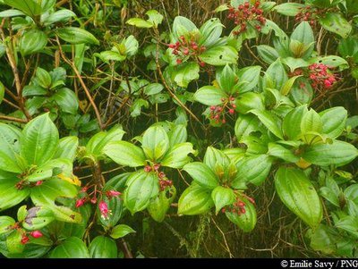
Palétuvier jaune - Emilie Savy / PNG FloraChewstick tree
Symphonia globulifera, also commonly known as the chewstick tree, belongs to the Clusiaceae family. The tree grows in thick, humid and swampy forests. Reaching up to 25-30 metres in height, it has stilt roots and a yellow latex trunk. Its flowers are formed of bright red petals, while its fruits resemble nutmeg, are oval in shape and yellow when ripe. It wood was one used as timber for houses and resin for boats.
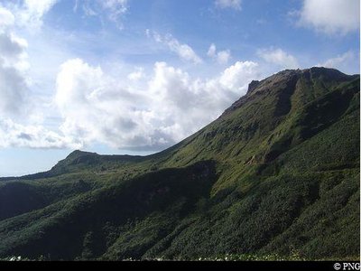
point de vue sur La Soufrière - PNG  Viewpoint
Viewpoint of La Soufrière
Viewpoint of La Soufrière, amid the treetops.
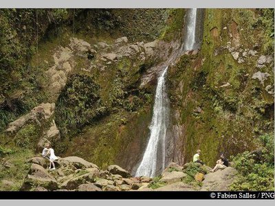
La Chute du Galion - Fabien Salles / PNG  River and waterfall
La Chute du Galion
Carved into the lava of the volcano, La Chute du Galion waterfall gushes forth from a height of 40 metres. The water at the source of the Galion is heated by the volcano, whose sulphur deposits account for its orange colour, but returns to a normal temperature by the time it reaches the bottom.
 History
La Trace de l'Armistice
This trail was named by walkers from the Mountaineers Club. The club tried it out for the first time on Armistice Day (11 November 1953), which commemorates the end of the First World War in 1918.
- Flora
The Yucca Plum Pine
Podocarpus coriaceus is also commonly known as the Yucca Plum Pine. It is a member of the Podocarpaceae family. Closely related to conifers, it is an average-sized tree, measuring around 10-16 metres. Its leaves – dark green on top – have a leathery quality that is reminiscent of the common oleander. They have a span of 6-15 cm with no discernible stalk. While its flowers are discreet, its brown-coloured seeds in their red floral buds are particularly eye-catching. It has a thin layer of bark. This species is found throughout the West Indies and flowers mainly in December and January.
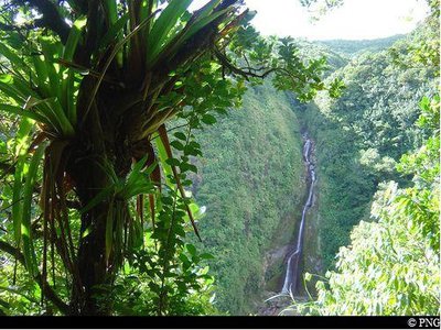
vue sur La Chute du Galion - PNG ViewpointViewpoint of La Chute du Galion
A gap in the vegetation provides stunning views of La Chute du Galion waterfall.
fruit du Clusia mangle - Fabien Salles / PNG FloraClusia mangle
The Clusia mangle is endemic to Guadeloupe. It thrives at 800 metres above sea level where winds are strong and humidity is constant. It is a shrub with leathery, fleshy and shiny leaves. Its fruits resemble large, yellow olives.
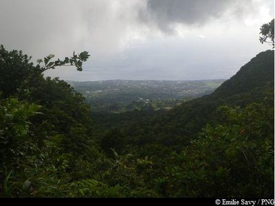
vue sur la Soufrière et le Nez Cassé - PNG ViewpointDébouché de l'Armistice
A viewpoint towards La Soufrière and Le Nez Cassé where the high forest opens out, before reaching the summit of La Citerne.
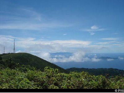
- Viewpoint
Viewpoint of Le Grand Etang
Looking south-east down towards Le Grand Etang, crossing the relay antennas towards the high voltage line.
Fuschia montagne - Emilie Savy / PNG FloraCharianthus alpinus
From the Melastomataceae family, Charianthus alpinus, commonly known in French as mountain fuchsia, is endemic to the Lesser Antilles. It measures between 1-2 metres in height. Its leaves are made up of five base veins and of particular interest are the fuchsia flowers, which attract hummingbirds.
vue sur Les Saintes ! - PNG ViewpointViewpoint of La Soufrière
From the old car park of Savane à Mulets, views of La Soufrière to the north and, on a clear day, of Les Saintes to the south.
vers Baillif ... - Emilie Savy / PNG ViewpointViews of Baillif
Views of Baillif to the west and Piton Tarade to the north-west.
Description
Hiking markup: yellow.
From the parking area of Bains Jaunes, take the paved trail (Le Pas du Roy). At the intersection, leave the access to La Soufriere on the left and turn right in the direction of La Chute du Galion waterfall. Continue straight on the road that crosses several gullies.
On arriving at the Galion river, cross it and join the trail on the other side. Possibility to turn left to go to the foot of the waterfall; use the ropes on the last few metres to climb the rock. Then return to the previous intersection. Otherwise (or later) at the junction, follow the signs to the "Citerne par L'Armistice" going straight. Take the trail that goes up. Enjoy waterfall viewpoint, and continue the steep climb through the mud and roots.
On arrival at the dome, stay on the trail and walk around the Citerne on the right. After enjoying the view (on clear days), take the direction to Savane à Mulets on the concrete road. At Savane à Mulets, go down the road for about 200 metres and then turn left towards Le Pas du Roy then on to Bains Jaunes. Jump in the hot pool at the parking area for a relaxing break !
- Departure : Bains Jaunes, Saint-Claude
- Arrival : Bains Jaunes, Saint-Claude
- Towns crossed : Saint-Claude, Gourbeyre, Trois-Rivieres, and Capesterre-Belle-Eau
Altimetric profile
Recommandations
Caution: River crossing. The route can be dangerous in wet conditions. Do not attempt it if it has rained the day before or if bad weather is forecast. If the water level rises, do not attempt to cross the river; wait until it recedes.
---
As Guadeloupe is prone to natural risks, extra care should be taken in this natural environment. For the benefit of all hikers, responsible behaviour is very important.
Please note : the parking and swimming areas are not supervised. Make sure you adhere to any rules issued by the Regional Health Agency concerning hot baths.
Information desks
Headquarters of the National Park of Guadeloupe
Montéran, 97120 Saint-Claude
The reception and shop are open to the public :
- Monday, Tuesday and Thursday : 8 am to 12.30 pm and 2 pm to 5 pm.
- Wednesday : from 8 am to 1 pm.
- Friday : 8 am to 12.30 pm.
Services : reception, shop, toilets, free parking. Building accessible to people with reduced mobility.
Localisation GPS : Lat: 16,01634 N - Lng: 61,70753 W.
Access and parking
GPS coordinates of the start point : Lat : 16,03459 N - Long : 61,6701 W.
Go through the town of Saint-Claude, passing the post office and the university. Continue uphill on Route RD11, passing through the picnic area of Beausoleil. Keep going until the end of the road and park at the Bains Jaunes parking area, using one of the spaces provided. (The Savane à Mulets parking area and main access road are closed to traffic because of potential landslide risk).
Parking :
More information
Source
Report a problem or an error
If you have found an error on this page or if you have noticed any problems during your hike, please report them to us here: