Galion river waterfall
Attachment
- Downloadpdf
Les sources hydrothermales du massif de la Soufriere
Credit: fiche pédagogique BRGM au sujet des sources hydrothermales du massif de la Soufriere - BRGM
8 points of interest
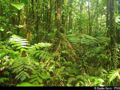
Figuier - Fabien Salles / PNG  Flora
FloraShortleaf fig
The shortleaf fig tree (Ficus citrifolia) is a member of the Moraceae family. It is quite a unique tree: as an epiphyte, it has the ability to grow on competing trees. Its aerial roots develop by dropping downwards and then branching out as the tree grows. It can strangle competing trees and kill them.
The shortleaf fig can grow both on the ground and on buildings.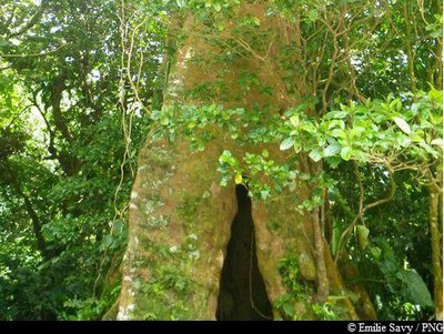
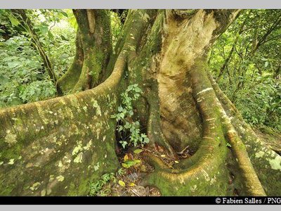
Acomat Boucan - Emilie Savy / PNG FloraAcomat boucan
The Acomat boucan (Sloanea caribaea) belongs to the Elaeocarpaceae family. It is an extremely large tree that can grow up to 40 metres tall. It is the most spectacular tree in the Sloanea genus. It has an exposed trunk and magnificent buttresses, with reddish-brown bark that starts to peel off into thin strips when the tree starts to age.
Formerly, visitors to the forest would make use of its enormous buttresses to shelter their fires and to smoke meat. It has since been established that lighting fires among the roots is not conducive to the well-being of trees.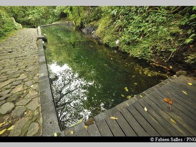
le bassin des Bains Jaunes - Fabien Salles / PNG  Area of relaxation
Les Bains Jaunes
Set amid the forest of the same name, the site of Les Bains Jaunes has long been a popular destination. The first dwellings here were the ajoupa of the Igneri people, followed by mouina of the Carib Indians.
Many years later, it became an important stopping-off point on the road to La Soufrière. In the late nineteenth century, the soldiers from Saint-Claude built a convalescent home and shooting range. Around 1910, the famous Mountaineers Club erected a makeshift shelter and later, in 1947, the Renaissance association built their own shelter, designed for hikers and swimmers. That building was later to become the Maison du Volcan, which has since closed. It is thanks to the soldiers of the Marine Infantry, who were sent to Bains Jaunes in order to "acclimatise themselves", that a stone lagoon - still in place today - was built in 1887.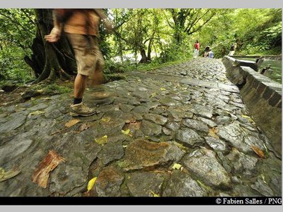
sentier du Pas du Roy - Fabien Salles / PNG  History
Le Pas du Roy
"Lest we forget that we owe the current path of Le Pas du Roy to the battalion commander, Mr. Legot. He replaced the old path that was originally mapped out by Mr. Rollin in January 1885 to guide the Count and Countess of Bardy to La Soufrière." Gérard Werter, "Coureur des Bois".
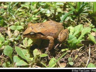
Hylode de la Martinique - Guy Van-Laere / PNG  Fauna
FaunaThe frogs of Guadeloupe
There are two endemic species of frog in Basse-Terre: Hylode de Barlagne (Eleutherodactylus barlagnei) and Hylode de Pinchon (Eleutherodactylus pinchoni), and if you listen carefully you might just hear them ribbiting at Pas du Roy. Both species are dark in colour and measure 2-3 centimetres in length. But, the most common species in Guadeloupe is the Martinique Robber Frog (Eleutherodactylus martinicencis).
Palétuvier jaune - Emilie Savy / PNG FloraChewstick tree
Symphonia globulifera, also commonly known as the chewstick tree, belongs to the Clusiaceae family. The tree grows in thick, humid and swampy forests. Reaching up to 25-30 metres in height, it has stilt roots and a yellow latex trunk. Its flowers are formed of bright red petals, while its fruits resemble nutmeg, are oval in shape and yellow when ripe. It wood was one used as timber for houses and resin for boats.
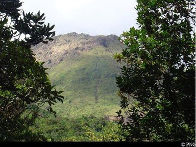
point de vue sur La Soufrière - PNG  Viewpoint
Viewpoint of La Soufrière
Viewpoint of La Soufrière, amid the treetops.
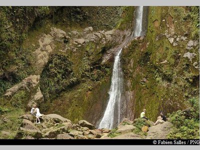
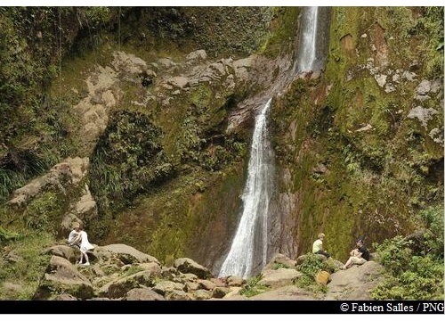
La Chute du Galion - Fabien Salles / PNG  River and waterfall
La Chute du Galion
Carved into the lava of the volcano, La Chute du Galion waterfall gushes forth from a height of 40 metres. The water at the source of the Galion is heated by the volcano, whose sulphur deposits account for its orange colour, but returns to a normal temperature by the time it reaches the bottom.
Description
Hiking trail colour: yellow
From the Bains Jaunes car park, go past the hot baths, follow the yellow signs and take the "Pas du Roy" paved walkway.
When you come to the intersection, ignore signs to La Soufrière to the left and take a right towards La Chute du Galion. Keep going on the path, which cuts through a number of ravines. Cross the Galion river carefully, making sure not to slip on the rocks. You rejoin the path on the other side. Turn left until you reach the base of La Chute du Galion. Use safety ropes for the last few metres when climbing the rock. Enjoy the views of the waterfall and the Saintes archipelago to the south, before heading back to the intersection, paying attention to the rocky descent. Head back across the river and take the same path for the journey back. When you reach the end, you may even wish to enjoy the hot baths.
- Departure : Bains Jaunes, Saint-Claude
- Arrival : Bains Jaunes, Saint-Claude
- Towns crossed : Saint-Claude
Altimetric profile
Recommandations
Caution: River crossing. The route can be dangerous in wet conditions. Do not attempt it if it has rained the day before or if bad weather is forecast. If the water level rises, do not attempt to cross the river; wait until it recedes.
---
As Guadeloupe is prone to natural risks, extra care should be taken in this natural environment. For the benefit of all hikers, responsible behaviour is very important.
Make sure you adhere to any rules issued by the Regional Health Agency concerning hot baths.
Please note : the parking and swimming areas are not supervised.
Information desks
Headquarters of the National Park of Guadeloupe
Montéran, 97120 Saint-Claude
The reception and shop are open to the public :
- Monday, Tuesday and Thursday : 8 am to 12.30 pm and 2 pm to 5 pm.
- Wednesday : from 8 am to 1 pm.
- Friday : 8 am to 12.30 pm.
Services : reception, shop, toilets, free parking. Building accessible to people with reduced mobility.
Localisation GPS : Lat: 16,01634 N - Lng: 61,70753 W.
Access and parking
GPS coordinates of the start point : Lat : 16,03459 N - Long : 61,6701 W.
Go through the town of Saint-Claude, passing the post office and the university. Continue uphill on Route RD11, passing through the picnic area of Beausoleil. Keep going until the end of the road and park at the Bains Jaunes parking area, using one of the spaces provided. (The Savane à Mulets parking area and main access road are closed to traffic because of potential landslide risk).
Parking :
Source
Report a problem or an error
If you have found an error on this page or if you have noticed any problems during your hike, please report them to us here: