Bisdary downhill track (MTB)
The municipality of Gourbeyre, in partnership with the Ministry of Ecology, has set up this facility as part of the "TEPCV" programme (positive energy territory for green growth).
Description
Starting in Bisdary, the trail runs through the forest to Rivière-Sens. The trail is 500m long and has a 70m descent, taking you in just a few minutes to the marina.
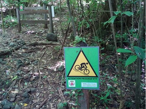
Follow the blue markings for mountain bikes.
NB: this mountain-bike descent is in a section of the "Tour du Houëlmont" hiking trail.
- Departure : Gourbeyre, Bisdary, Rue des Archives.
- Arrival : Gourbeyre, Rivière-Sens, Rue de L'Espadon.
- Towns crossed : Gourbeyre
Altimetric profile
Recommandations
Don't over-estimate your capacities and keep your speed under control. Be careful and courteous when overtaking or passing hikers, since pedestrians have priority.
Check on the condition of your bike, take food and drink with you, as well as a repair kit.
This is a permanent trail open to all with each person responsible for its upkeep.
Please note: unsupervised car parks.
Information desks

46 rue Paul Baudot, 97100 Basse-Terre

rond point "Dos d'Ane", Valkanaërs, 97113 Gourbeyre
Access and parking
GPS starting point: 15,98588° N - Long: 61,71278° W.
---
Arriving by the RN1 road, in Gourbeyre, head for Blanchet, Bisdary. Then go towards the stadium, after the Departmental Archives building.
Source
Report a problem or an error
If you have found an error on this page or if you have noticed any problems during your hike, please report them to us here: