From Petit Havre to Anse à Saint
Le Gosier Coastal trail
From Petit Havre to Anse à Saint
Medium
2h
3,6km
+146m
-146m
Cross
PR (short hike network)
Embed this item to access it offline
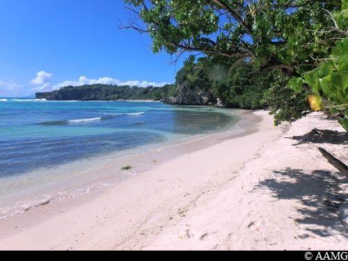
The series of hills and descents on the first part of the trail, although quite short, mean this trail is listed as of average difficulty. What's more, the heat can be intense. Don't forget to take at least 1.5 litres of water per person... and you can of course enjoy a swim in a number of different places !
8 points of interest
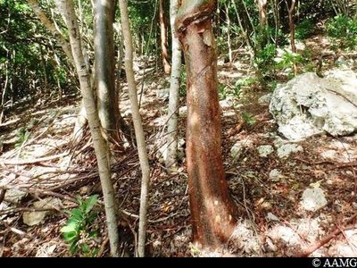
Gommier rouge - AAMG  Flora
FloraGumbo-Limbo
This tree is easy to spot, and you will see it all along the trail. So we might as well talk about it right from the start! It stands out with its red-brown bark which peels away in fine strips (which is why it is nicknamed "the tourist tree" in the Caribbean islands, since it "peels"!). When the trunk is cut, a fragrant white sap oozes out. It is considered as an anti-inflammatory and healing agent. Scientific name is Bursera simaruba.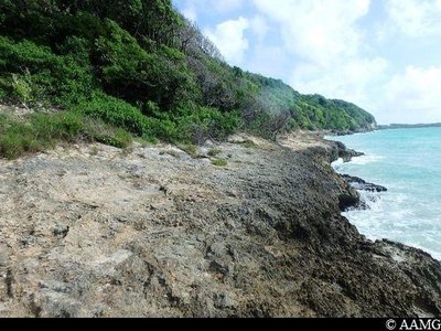
caye - AAMG  Geology
Section on the cay
This section over the old coral reefs reveals an essential aspect of the geological history of Grande-Terre. It was originally a volcanic island, with the surface below sea level for millions of years. This led to the development of the limestone plateau we can see today.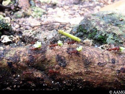
Fourmis manioc - AAMG  Fauna
FaunaAcromyrmex octospinosus
You will probably notice these ants coming and going along the trail. In French they are known as "manioc ants" or "parasol ants". You will soon see why! The plants the ants carry are used as compost. They grow a mushroom on the compost as food. The compost is kept at constant temperature and humidity levels up to 2 metres below the ground! The ants were introduced into Guadeloupe in the 1950s with imported vegetables. They are considered as an invasive species. Scientific name is Acromyrmex octospinosus.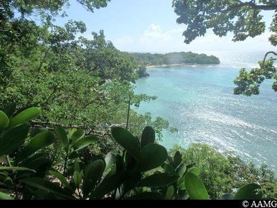
point de vue - AAMG  Viewpoint
Panorama
To the left is Petit-Havre beach. If you turn towards the sea, near the headland, you will often spot surfers. Out to sea, it is easy to locate Marie-Galante. On a clear day, you can even see Dominica (to the right of Marie-Galante). Lastly, you will definitely be able to spot Les Saintes (at least the mountain tops!), and Basse-Terre, on the far right.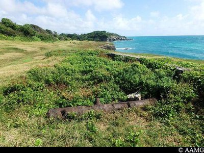
canon - AAMG  History
Old fortress – Pointe de Petit-Havre
This site, like many other headlands in Guadeloupe, was strategically very important. In the 18th century, the struggle between the English and French was raging, with each nation seeking to take control of the island. At the sight of enemy ships, a red flat was hoisted and lowered the same number of times as there were enemy vessels... The range of a cannon of this kind was over 3 km!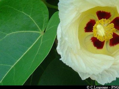
Fleur du Catalpa - PNG FloraPortia tree - Anse à Jacques
A very common tree on the Guadeloupe coast, often mistaken for the dangerous manchineel tree (see below)... but very different in the shape of its leaves, which are a pretty heart shape! It has beautiful flowers which turn from yellow to pink at different stages of its life. The fruit is ribbed, green and then brown, and floats in the sea. The scientific name is Thespesia populnea.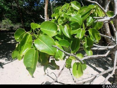
Mancenillier - AAMG FloraManchineel tree
This is a tree that you should absolutely learn to recognise! It is well adapted to the coast, and you often see them. These trees help to fight the erosion of the beaches, but they are very dangerous. All parts of the tree have a toxic sap that causes burns. It is not recommended to take shelter under one if it rains. Notice its pointed leaves. Scientific name is Hippomane mancinella.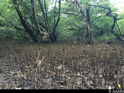
AAMG FloraAerial roots
White or black mangrove roots. The roots enable the trees to breathe in soils lacking oxygen. They act like a diver's snorkel. The height of the roots shows the water level during flooding.
Description
The trail with its yellow markings begins to the left of the beach, near the ONF panel "forêt domaniale du littoral". You make your way under the forest cover alongside the cliff, sometimes in the hills, sometimes near the water, with sections directly overlooking the cay (old coral reefs which are sometimes quite sharp). Some sections (both climbs and descents) are tricky, so be careful! After 1 hour 20 minutes, you arrive at the beach in the aptly named Petit-Havre (Little Haven)! You have to cross the rear of the beach and find the path just behind a karbay, near the fishermen's cabins. You then arrive at a headland with the remains of a stronghold and a cannon. This a great site with a wonderful view. You continue the trail to the left of the cannon and leading back into the forest. After 5 minutes, you arrive at L’Anse à Jacques. Cross the bay. The trail continues on the other side, slightly behind the beach (a slight climb up a small hill). After crossing L’Anse Patate, you will soon arrive at L’Anse à Saint, the end of our trail. Then walk towards Morne Jacques to get to the road and the car park.
- Departure : Salines beach car park, Gosier.
- Arrival : Anse à Saint beach, Gosier (near Petit Havre beach).
- Towns crossed : Le Gosier and Sainte-Anne
Altimetric profile
Recommandations
NB: this is a non-circular trail, so you should leave your car at the end of the trail (in L'Anse à l'Eau).
---
Enclosed shoes required. Minimum 1.5 L of water per person (one way). A snack and... a swimsuit!
Please note, unsupervised car parks and swimming.
---
Enclosed shoes required. Minimum 1.5 L of water per person (one way). A snack and... a swimsuit!
Please note, unsupervised car parks and swimming.
Information desks
Office du tourisme du Gosier
rue Félix Eboué, 97190 Le Gosier
Access and parking
GPS starting point: Lat: 16,20704° N - Long: 61,44281° W.
---
The trail starts from the Salines beach car park. On the N4, after Le Gosier on the road to Sainte-Anne, you go past Saint-Félix, then the starting point will be on your right (sign for Les Salines).
---
The trail starts from the Salines beach car park. On the N4, after Le Gosier on the road to Sainte-Anne, you go past Saint-Félix, then the starting point will be on your right (sign for Les Salines).
Parking :
Start: Salines beach car park. Finish: Anse à Saint, Gosier (near Petit Havre beach).
Source
Rando Guadeloupehttps://www.randoguadeloupe.gp/
Report a problem or an error
If you have found an error on this page or if you have noticed any problems during your hike, please report them to us here: