From Trois Pointes to Pointe Plate
Vieux-Fort Coastal trail
From Trois Pointes to Pointe Plate
Easy
1h
1,9km
+77m
-87m
Cross
Embed this item to access it offline
Come and recharge your batteries in this region at the tip of Guadeloupe !
8 points of interest
PNG  Area of relaxation
Picnic area
The Trois Pointes visitors' centre provides the public with a unique seaside window onto Monts Caraïbes, the town of Basse-Terre, the Vieux-Fort lighthouse and a breathtaking perspective over the sea!
Native Americans once lived in this seaside site.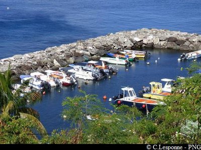
Anse Dupuy - PNG  Viewpoint
Panorama
View over Anse Dupuy, a fishing port in the municipality of Vieux-Fort.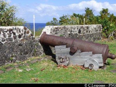
PNG  Cultural and architectural heritage
Fort l'Olive
Originally known as "Vieux-Fort L'Olive" as a homage to its builder, Charles de L'Olive (Governor in 1636), then Vieux-Fort, the municipality is named after him.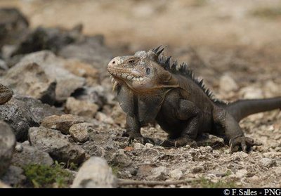
Iguane des Petites Antilles - PNG  Fauna
FaunaIguanas
The lesser Antillean iguana, Iguana delicatissima, is endemic to the Lesser Antilles.
The species is endangered due to the invasion of another species, the green iguana (Iguana iguana).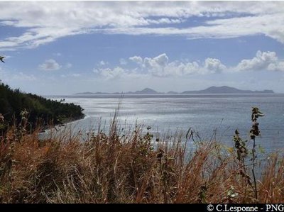
PNG ViewpointPanorama
A fine view over Les Saintes.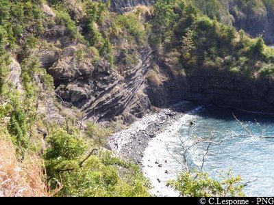
PNG  Geology
Pointe Henriette
The volcanic geology produced shapes sculpted by marine erosion in the basalt rock. Near Pointe Henriette you can see a colony of pelicans. These birds can eat up to 6 kg of fish a day.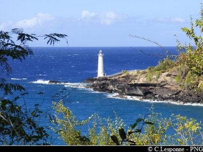
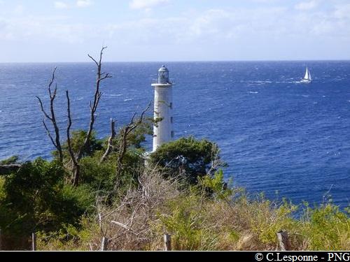
PNG Viewpointview of the Vieux-Fort lighthouse
The lighthouse is one of the few still operating in Guadeloupe. A symbol of the municipality of Vieux-Fort, it stands at the far south and guides ships between the Canal des Saintes and Basse-Terre harbour.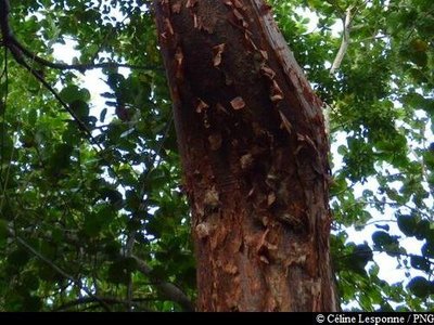
Gommier rouge - PNG  Flora
FloraGumbo-Limbo
The Gumbo-limbo (Bursera simaruba) is a typical dry-forest tree. It is easy to spot with its red bark that peels off in strips. Under the strips the bark is smooth and green.
Description
Trail signs: Conservatoire du Littoral (Coastal Conservatory).
---
Follow the path beginning behind the picnic area. Continue along the coastal path. When you get to the top of Anse Dupuy (do not go down), continue along the road to Fort Olive. Cross the Fort Olive site, then carry on along the little footpath behind it, towards the lighthouse. Cross the car park, then head towards the picnic karbays opposite. Continue along the footpath towards Pointe Henriette, then all the way to end of the trail behind the houses in Pointe Plate.
- Departure : the Trois Pointes site, Vieux-Fort coast.
- Arrival : Pointe Plate, sports office, Vieux-Fort.
- Towns crossed : Vieux-Fort
Altimetric profile
Recommandations
NB: this is a non-circular trail, so you should leave your car at the end of the trail.
---
In this natural setting, you should be particularly careful and alert, especially since Guadeloupe is subject to natural risks. It is vital to act in a responsible way, so that everyone can enjoy the hike!
Please note: unsupervised car parks and swimming.
---
In this natural setting, you should be particularly careful and alert, especially since Guadeloupe is subject to natural risks. It is vital to act in a responsible way, so that everyone can enjoy the hike!
Please note: unsupervised car parks and swimming.
Information desks


46 rue Paul Baudot, 97100 Basse-Terre
Access and parking
GPS starting point: 15,95513° N - Long: 61,70901° W.
---
Arriving from the Rivière-Sens marina, on the RD6 coastal road: the hike begins before you arrive in the town of Vieux-Fort, at the Mazarin/3 Pointes picnic area.
If you arrive from Trois-Rivières (RD6): the hike begins at the edge of the town of Vieux-Fort, at the Mazarin/3 Pointes picnic area.
Parking :
Departure: Trois Pointes car park; arrival at the Vieux-Fort sports office.
Source
Rando Guadeloupehttps://www.randoguadeloupe.gp/
Report a problem or an error
If you have found an error on this page or if you have noticed any problems during your hike, please report them to us here: