From Anse à l'Eau to Anse Montal
Saint-Francois Coastal trail
From Anse à l'Eau to Anse Montal
Difficult
5h
9km
+193m
-202m
Cross
PR (short hike network)
Embed this item to access it offline
Grande Terre in all its splendour. Sunshine, heat, aridity, jagged cliffs and coastal vegetation. It's breathtaking!
11 points of interest
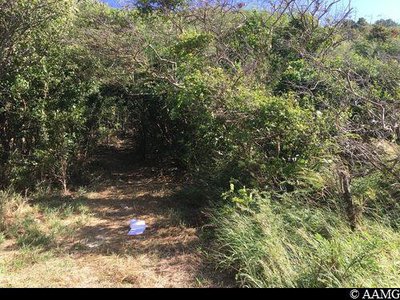
chemin en sous-bois - AAMG  Viewpoint
path through the undergrowth
Just after the gate, enter the undergrowth.
Take care, there is a steep climb. Viewpoint
panorama
A superb panorama with the chance to get your breath back after the climb.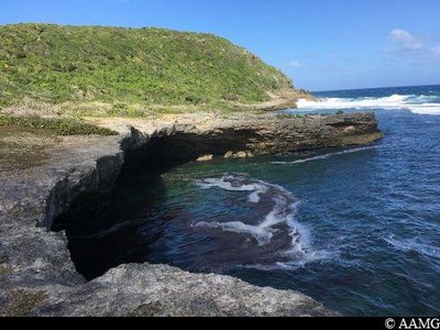
La Cuve - AAMG  Geology
La Cuve
The magnificent scenery here resulted from the action of the sea on the limestone rock (geological curiosity).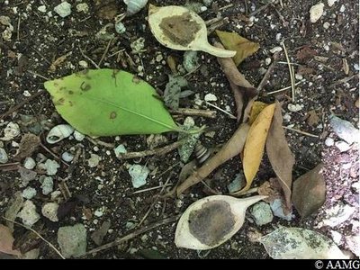
Bois Savonnette - AAMG  Flora
FloraSavonnette
Several plants are known as "savonnette" in the West Indies. This one (lonchocarpus puncatus) lives in the dry (xerophile) or mesophile forest. It has clusters of pink blossom. The leaves are used in hot baths.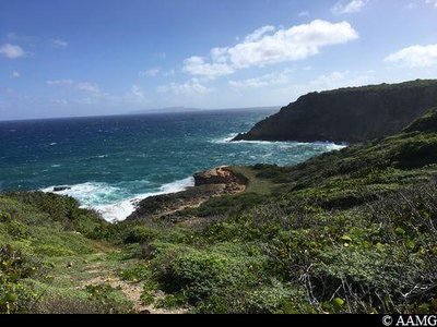
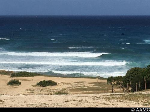
vue sur Anse Petite Savane - AAMG ViewpointView over Anse Petite Savane
The clear view over the descent towards Anse Petite Savane inspires hikers to take a break.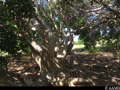
Mapou Gris - AAMG FloraMapou tree
The Mapou (Pisonia Subcordata) is a tree with a large trunk and big, sinuous branches. The wood is of little value, since it rots quickly. The tree likes limestone soil. It is very common in Guadeloupe and quite rare in Martinique.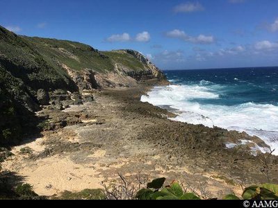
AAMG ViewpointDangerous section
The view is wonderful, but this section is DANGEROUS. There is a rope to help you go up and down. The most dangerous section is just after the rope ends on the way up. You have to walk over a rock slide. There is just enough room for your feet.
If you are afraid of heights, don't continue.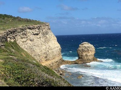
AAMG GeologyPorte d'Enfer cliffs
This is a panorama above La Porte d'Enfer in Le Moule, with a small white sandy beach below the cliff.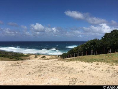
Anse Salabouelle - AAMG ViewpointAnse Salabouelle
Anse Salabouelle, a surfers' paradise.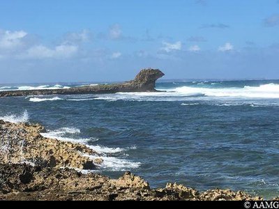
AAMG GeologyPointe de la Couronne Conchou
A rocky limestone headland projecting into the sea.
Imaginative visitors say it looks like a sphinx.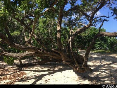
Palétuvier noir - AAMG FloraBlack mangrove
The Black Mangrove (Avicennia germinans) was often used in the colonial period to make charcoal. The bark was used in tanning. It contains a yellow tannin.
Bees seek out this wood to make a much-appreciated honey.
Description
Walk to the west, leaving the Anse à l'Eau beach behind you. After a few yards, you will see the remains of a gate. Turn right there into the undergrowth (the sign has been taken down but the markings are still there). The climb is a bit steep. At the top, the trail leads to the left. But you should go up and back to see the view. The path goes back down, crosses a path and enters the undergrowth again. You then arrive in the savannah. Go there and back to see a geological curiosity, "La Cuve" (point 1). Follow the markings through the undergrowth. Cross a gully before another very steep climb which then falls gently towards the gully. Walk along the gully, keeping your eyes to the right. The path heads upwards to the right. At the top take the path to the left (the trail heading straight on is interesting but more difficult). You arrive in the savannah. Turn right. You will see another great view. Here, a well-marked path goes to the left, but don't take it. Continue a few yards and enter the undergrowth. You will see the markings. The markings a little further on are there to confirm you are going the right way. The walk continues at the top of the cliff and makes its way between the woodland and savannah. When you get to Anse Gros Morne (point 2), you will see a sign pointing two ways:
Option 1: along a path, easy level, but no markings. Follow the path as far as the road. Turn right, go past the clinic and walk along the road for 300 metres. Take the path into the fields on the right. Go straight ahead through the undergrowth and you will arrive back on the path.
Option 2: via the coast, very difficult level, even dangerous. After going round the clinic to the right. Go down the Gros Morne (there is a rope). The path leads up to the cliff on the left (there is a rope). The path continues over the rock slide, 30 cm from the precipice.
The trail moves into a more peaceful setting. You arrive on a tarmac road. A visit to Porte d'Enfer ("Gates of Hell") is in order. Otherwise, the path continues on the other side of the road and in the undergrowth.
Continue the trail, passing in front of L'Anse Salabouelle. You then pass La Pointe Conchou. The end of the trail is a little further on, at the Dauphins beach.
- Departure : Anse à l'Eau, Saint-François.
- Arrival : Plage des Dauphins, Anse Montal, Moule.
- Towns crossed : Saint-Francois and Le Moule
Altimetric profile
Recommandations
NB: this is a non-circular trail, so you should leave your car at the end of the trail.
Be careful, there is a dangerous section at the edge of the cliff (Anse Gros Morne).
In this natural setting, you should be particularly careful and alert, since Guadeloupe is subject to natural risks. It is vital to act in a responsible way, so that everyone can enjoy the hike!
Please note: unsupervised car parks and swimming.
Information desks

2 rue Gambetta, 97117 Port-Louis

avenue de l'Europe, 97118 Saint-François
Access and parking
GPS starting point location: 16,30699° N - Long: 61,26743° W.
---
The trail starts in Anse à l'Eau in the municipality of St François.
When you arrive from Le Moule in the direction of St François, take the N5 road, go past La Maison Zévallos and, just after the first bend, turn left towards St Louis. Go straight ahead as far as the beach (Be careful, the end of the road is damaged).
Parking :
Start: Anse à L'Eau. Finish: L'Anse Montal beach.
Source
Rando Guadeloupehttps://www.randoguadeloupe.gp/
Report a problem or an error
If you have found an error on this page or if you have noticed any problems during your hike, please report them to us here: