La Soufrière from l'Echelle
Attachment
- Downloadpdf
Les sources hydrothermales du massif de la Soufriere
Credit: fiche pédagogique BRGM au sujet des sources hydrothermales du massif de la Soufriere - BRGM
29 points of interest
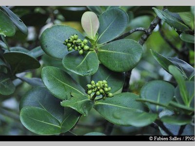
Figuier - Fabien Salles / PNG  Flora
FloraShortleaf fig
The shortleaf fig tree (Ficus citrifolia) is a member of the Moraceae family. It is quite a unique tree: as an epiphyte, it has the ability to grow on competing trees. Its aerial roots develop by dropping downwards and then branching out as the tree grows. It can strangle competing trees and kill them.
The shortleaf fig can grow both on the ground and on buildings.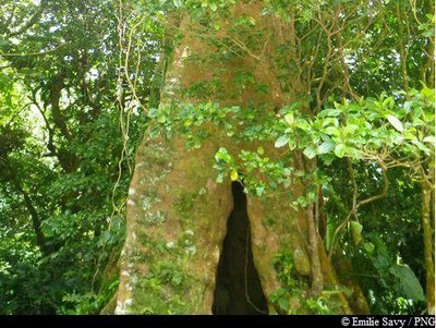
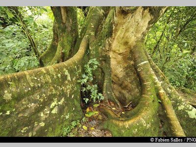
Acomat Boucan - Emilie Savy / PNG FloraAcomat boucan
The Acomat boucan (Sloanea caribaea) belongs to the Elaeocarpaceae family. It is an extremely large tree that can grow up to 40 metres tall. It is the most spectacular tree in the Sloanea genus. It has an exposed trunk and magnificent buttresses, with reddish-brown bark that starts to peel off into thin strips when the tree starts to age.
Formerly, visitors to the forest would make use of its enormous buttresses to shelter their fires and to smoke meat. It has since been established that lighting fires among the roots is not conducive to the well-being of trees.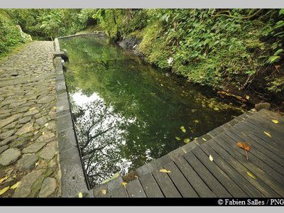
le bassin des Bains Jaunes - Fabien Salles / PNG  Area of relaxation
Les Bains Jaunes
Set amid the forest of the same name, the site of Les Bains Jaunes has long been a popular destination. The first dwellings here were the ajoupa of the Igneri people, followed by mouina of the Carib Indians.
Many years later, it became an important stopping-off point on the road to La Soufrière. In the late nineteenth century, the soldiers from Saint-Claude built a convalescent home and shooting range. Around 1910, the famous Mountaineers Club erected a makeshift shelter and later, in 1947, the Renaissance association built their own shelter, designed for hikers and swimmers. That building was later to become the Maison du Volcan, which has since closed. It is thanks to the soldiers of the Marine Infantry, who were sent to Bains Jaunes in order to "acclimatise themselves", that a stone lagoon - still in place today - was built in 1887.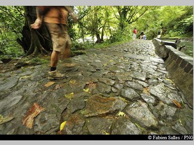
sentier du Pas du Roy - Fabien Salles / PNG  History
Le Pas du Roy
"Lest we forget that we owe the current path of Le Pas du Roy to the battalion commander, Mr. Legot. He replaced the old path that was originally mapped out by Mr. Rollin in January 1885 to guide the Count and Countess of Bardy to La Soufrière." Gérard Werter, "Coureur des Bois".
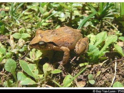
Hylode de la Martinique - Guy Van-Laere / PNG  Fauna
FaunaThe frogs of Guadeloupe
There are two endemic species of frog in Basse-Terre: Hylode de Barlagne (Eleutherodactylus barlagnei) and Hylode de Pinchon (Eleutherodactylus pinchoni), and if you listen carefully you might just hear them ribbiting at Pas du Roy. Both species are dark in colour and measure 2-3 centimetres in length. But, the most common species in Guadeloupe is the Martinique Robber Frog (Eleutherodactylus martinicencis).
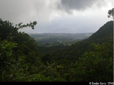
vers Baillif ... - Emilie Savy / PNG  Viewpoint
Views of Baillif
Views of Baillif to the west and Piton Tarade to the north-west.
vue sur Les Saintes ! - PNG ViewpointViewpoint of La Soufrière
From the old car park of Savane à Mulets, views of La Soufrière to the north and, on a clear day, of Les Saintes to the south.
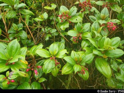
Fuschia montagne - Emilie Savy / PNG FloraCharianthus alpinus
From the Melastomataceae family, Charianthus alpinus, commonly known in French as mountain fuchsia, is endemic to the Lesser Antilles. It measures between 1-2 metres in height. Its leaves are made up of five base veins and of particular interest are the fuchsia flowers, which attract hummingbirds.
vue sur le lac Flammarion - Fabien Salles / PNG ViewpointView of the crater of la Citerne
Volcanic activity has been happening inside and on the edges of the Amic crater for 3,000 years. Three magmatic eruptions followed: bringing about the Amic volcanic dome, the cinder domes of l'Echelle and la Citerne and finally, the eruption which took place around 1515 and resulted in the creation of the current dome of La Soufrière. La Citerne is a wide, unevenly-shaped funnel, around 50 metres deep. At its foot is a lake called Lac Flammarion, named after the famous French astronomer Camille Flammarion.
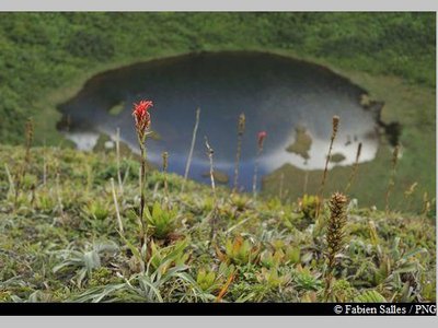
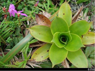
broméliacée - PNG FloraPitcairnia bifrons
A member of the Bromeliaceae family, Pitcairnia bifrons is a herbaceous plant endemic to the Lesser Antilles. Ranging between 80 cm and 1 metre tall, its leaves - located at ground level - are in the form of a rosette. It has a high inflorescence, with red/scarlet flowers.
Clusia mangle - Fabien Salles / PNG FloraClusia mangle
Clusia mangle is a member of the Clusiaceae family.
Endemic to the Lesser Antilles, it thrives at 800 metres above sea level, where there are strong winds and constant humidity. It is a shrub with leathery, fleshy and shiny leaves. Its fruits, which are between 1-2 centimetres, are similar to big yellow/green olives.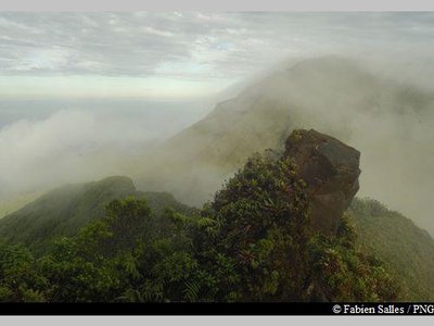
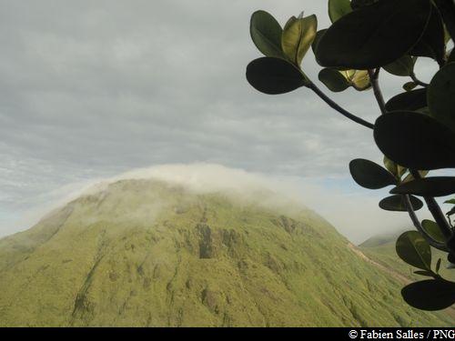
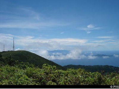
Au sommet de l'Echelle - Fabien Salles / PNG  Summit
Top of l'Echelle
Top of l'Echelle, at 1,397 metres above sea level.
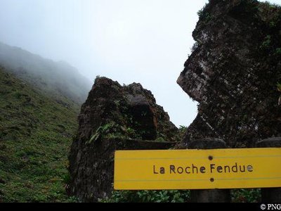
la Roche Fendue - PNG  Geology
La Roche Fendue
Prior to the eruption in 1976, there were three openings here and a serious of fumaroles - a marquis visitor attraction. The 1976 eruption was phreatic, meaning that the magma did not reach the surface but came into contact with groundwater, which subsequently underwent a pressure surge. Violent explosions then spewed forth old volcanic materials (rock and ash) and caused numerous earthquakes. During this dramatic period, one block struck this enormous rock and split it in two; it then became la "Roche Fendue" (The Split Rock). In 1976, during this period of volcanic activity, the population of the southern part of Basse-Terre had to be evacuated for several months.
 Geology
Source of the Carbet river
There is a noticeable rockslide on the path, upstream of the pool towards the Carbet river. Sometimes fumaroles can be seen here.
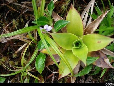
broméliacée (ananas) - PNG FloraGuzmania plumieri
A member of the Bromeliacieae family, Guzmania plumieri is a tropical grass. An epiphytic (growing on tree branches) or terrestrial plant, there are 40 species of it. Its leaves are upright, rigid, thick and arranged in the form of a rosette and take in a lot of water, making them a very popular home for frogs. It features a yellow floral scarp in the middle.
Graine bleue montagne - Fabien Salles / PNG FloraPsychotria aubletiane
Psychotria aubletiane, known in Creole as "Ipeka bata", is a member of the Rubiaceae family. It is a wetland shrub with upright branches. It features elliptical leaves, white flowers and fruits in small drupes that become a bright blue.
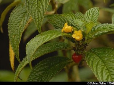
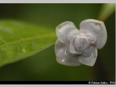
"Bois graine rouge" - Fabien Salles / PNG FloraBesleria lutea
Besleria lutea is a virtually perennial shrub with a shiny yellow inflorescence. It has dark green, leathery leaves and red berries.
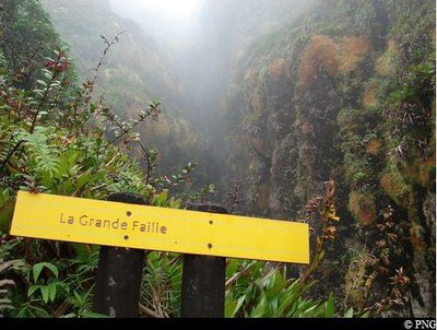
La Grande Faille - PNG GeologyLa Grande Faille
"La Grande Faille (The Great Fault) of the north, at around 100 metres deep and 3-4 metres wide, crosses La Soufrière from north to south [...]. In its northern section, it featured a chasm measuring 15 metres long, covered with a thick layer of sulphur crystals, which has been given the rather grand name of "Lac de Soufre" (Sulphur Lake)." Gérard Werter, "Coureur des Bois". On account of erosion caused by rainwater, sulphur powder has completely disappeared.
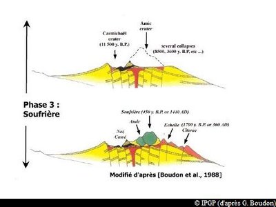
Formation de la Soufrière (phase 3) - IPGP (d'après G. Boudon) GeologyHow La Soufrière was formed
La Soufrière is part of a recently-formed volcanic complex, situated in the south of Basse-Terre. It consists of two formations: the composite volcano of la Grande Découverte, whose last activity resulted in the creation of La Soufrière, and the smaller volcanic complex of la Madeleine - located to the southeast of the former.
There were three primary phases behind the formation of La Découverte.
* 200,000-42,000 years ago : Grande Découverte phase.
On the south side of the Pitons de Bouillante and Sans Toucher: alternating lava flow stages and pyroclastic stages. These brought about the formation of the Grande Découverte caldera, of which only the northern wall remains visible today.
* 42,000-11,500 years ago : Carmichaël phase.
Formation of the Carmichaël massif, dominated by lava flows, within the Grande Découverte caldera. Two successive eruptions destroyed the uppermost part of the volcano.
* 8,500 years ago - present : Soufrière phase.
Eruptions took place largely within or on the rims of the Amic crater. Three magmatic eruptions followed, giving rise to the current form of La Soufrière and l'Echelle.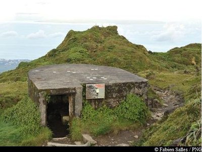
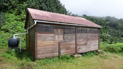
abri de la Soufrière - Fabien Salles / PNG  Mountain shelter
La Soufrière shelter
It was opened in 1935 by governor Bouge. Among the 1,000 people who climbed the volcano that day to attend the ceremony was Camille Thionville, the founder of the Mountaineering Club. He was 78 and this trip was to be his last hike of the volcano. At the time, it was common for hikers to spend the night in this small shelter.
Renovated in 1982, it is now open as a shelter in the event of bad weather.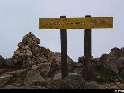
sommet de la Soufrière : "la Découverte" - PNG SummitTop of La Soufrière
Situated at 1,467 metres above sea level, La Découverte is the highest point in Guadeloupe and the Lesser Antilles. On a good day the views can be spectacular, but it is also extremely common for there to be gusts of 50 km/h! With bumps and stony crevices, the plateau at the summit of La Soufrière offers a lunar-like landscape in places. It was the French naturalist Felix Herminier who was responsible for the toponymy of the summit of La Soufrière.
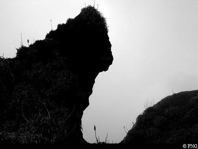
"La Guenon" de La Porte d'Enfer - PNG HistoryLa Porte d'Enfer
Here, at La Porte d'Enfer ("Hell's Gate"), bold and intrepid visitors to La Soufrière would complete their final ascent of the volcano. They stopped off half way through the Chemin des Dames and climbed the steep slope to reach it. It is guarded by La Guenon, a rock with a monkey-like face, which dominates one of the walls of this site. Not so far away from here, Le Piton Dolomieu (1,464m) is also visible. There are many names that allude to the infernal dimension of La Soufrière: la montagne à diables (devil mountain), le pont du diable (devil's bridge), la mare aux diables (devil pool), le diablotin (the little devil) and of course, la Porte d'Enfer itself.
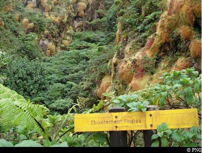
Eboulement Faujas - PNG GeologyThe Faujas landslide
This landslide was caused by a phreatic explosion in 1798. Blocks of stone, ash and mud overflowed onto Matouba (top of the village of Saint-Claude) and into the valley of the Rivière Noire. The landslide was named after a famous geologist from the late eighteenth century, Barthélémy Faujas de Saint-Fond.
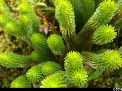
Lycopodes - PNG FloraClubmosses
The Lycopodium genus includes a number of species which are botanically similar to ferns and spikemosses. As pioneer plants, the Clubmosses are the first to settle on the ground after volcanic eruptions. Thanks to the abundant spores that are produced in their small and densely-packed refracted ears, found at the ends of the branches, they can multiply freely.
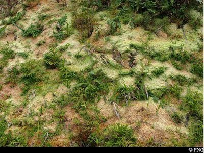
Sphaignes et mousses - PNG FloraPeat mosses and other mosses
In upland savannas, peat and other mosses form thick carpets, reminiscent of peatlands in cold areas or temperate highland areas. Peat mosses and mosses dominate the vegetation of La Soufrière and in virtually flat areas or in basins that are constantly waterlogged, where they live in almost aquatic conditions.
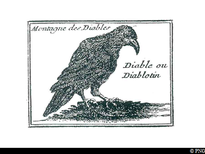
Le Diablotin - PNG FaunaLe Diablotin ("The Little Devil")
La Soufrière was once home to a bird named Le Diablotin ("The Little Devil"). This petrel nested in holes carved into the mountain sides. Living solely on a diet of fish, it left its home after dark to go fishing at sea. A highly-prized game bird, it disappeared from Guadeloupe in around 1880.
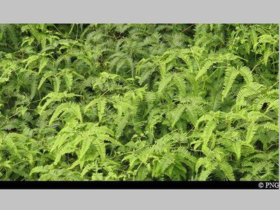
Fougère calumet - PNG FloraDicranopteris pectinata
Dicranopteris pectinata is a member of the Gleicheniaceae family. It is a pioneer species that is so typical of open and sunny areas. It colonises landslide areas, the edges of forest roads, river banks and, generally, any surfaces that have been severely stripped back in wet areas. This fern's network of underground roots plays a key role in consolidating the topsoil.
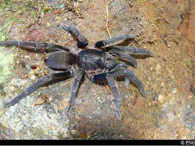
Mygale de la Soufrière - PNG FaunaHolothele sulfurensis
This species of spider (Holothele sulfurensis) can only be seen on La Soufrière massif, above 700 metres. It makes its home underneath rocks.
Dark brown in colour, it measures 1-2 cm. Despite being a tarantula, this particular species is not poisonous.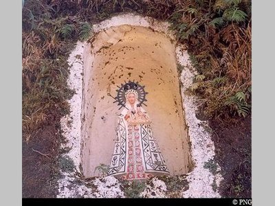
Notre-Dame de la Guadeloupe - PNG  Cultural and architectural heritage
Notre Dame de la Guadeloupe
After La Soufrière erupted in 1956, a statue of Notre Dame de la Guadeloupe was erected here, in a small chapel housed within the rock. The parishioners of Saint-Claude regularly adorn it with flowers and candles to give thanks to the volcano for its clemency.
Description
Hiking trail colour: yellow
Starting from the parking area of Bains Jaunes, take the "Pas du Roy" paved path. Leave the intersection for la Chute du Galion on the right and keep going uphill until Savane à Mulets. Go back up to the old parking area and keep right on the small, concrete road. Keep "Col de l'Echelle" on your left and follow the road towards la Citerne. Then take the steep trail to the left, following the signs to "Sommet de l'Echelle". Go uphill and past the top of l'Echelle. Come back down towards the bunker (formerly a geophysical shelter) and la Roche Fendue. The trail then heads off to the right. Pass le Col de l'Echelle and then take a left, leaving the path to Chutes du Carbet on the right. Turn left towards the top of La Soufrière, going round it at the base. Arriving north, leave the Carmichaël trail that heads towards the ridge and turn left. At the Grande Faille intersection, turn left again: the climb then gets quite steep. Once you have reached the top, go around the plateau of La Soufrière from the right, walking the shelter of the Mountaineering Club, the top of "La Découverte" and the chasms. Then head back towards la Grande Faille, keep going straight until la Savane à Mulets and return via the Pas du Roy trail. For a nice, relaxing break, head for the hot water springs back near the parking area.
- Departure : Bains Jaunes, Saint-Claude
- Arrival : Bains Jaunes, Saint-Claude
- Towns crossed : Saint-Claude, Gourbeyre, and Capesterre-Belle-Eau
Altimetric profile
Recommandations
As Guadeloupe is prone to natural risks, extra care should be taken in this natural environment. For the benefit of all hikers, responsible behaviour is very important.
Beware of sulphurous gas emissions, which are highly toxic: do not cross the protective barriers. In the event of bad weather at the summit plateau of La Soufrière, such as rain or fog, follow the yellow stakes in the ground carefully.
Please note : the parking and swimming areas are not supervised.
Make sure you adhere to any rules issued by the Regional Health Agency concerning hot baths.
Information desks
Headquarters of the National Park of Guadeloupe
Montéran, 97120 Saint-Claude
The reception and shop are open to the public :
- Monday, Tuesday and Thursday : 8 am to 12.30 pm and 2 pm to 5 pm.
- Wednesday : from 8 am to 1 pm.
- Friday : 8 am to 12.30 pm.
Services : reception, shop, toilets, free parking. Building accessible to people with reduced mobility.
Localisation GPS : Lat: 16,01634 N - Lng: 61,70753 W.
Access and parking
GPS coordinates of the start point : Lat : 16,03459 N - Long : 61,6701 W.
Go through the town of Saint-Claude, passing the post office and the university. Continue uphill on Route RD11, passing through the picnic area of Beausoleil. Keep going until the end of the road and park at the Bains Jaunes parking area, using one of the spaces provided. (The Savane à Mulets parking area and main access road are closed to traffic because of potential landslide risk).
Parking :
More information
Source
Report a problem or an error
If you have found an error on this page or if you have noticed any problems during your hike, please report them to us here: