Pointe à Lézard trail
Bouillante Coastal trail
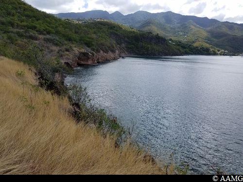
Pointe à Lézard trail
Easy
2h
3,6km
+198m
-198m
Loop
PR (short hike network)
Embed this item to access it offline
The walk is enhanced by a wide range of views over the Caribbean Sea as well as one of the many thermal springs in the area: the Bain du Curé.
9 points of interest
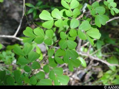
AAMG  Flora
FloraLogwood
A tree symbolising the dry forest, logwood (Haematoxylon campechianum) is characterised by its small, paired, heart-shaped leaves and thorns. It has a wide range of traditional uses. It is a very hard wood and is often used to make coal. It attracts bees and is popular with beekeepers.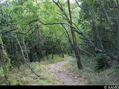
AAMG FloraDry forest
The xerophile forest lies on the least damaged dry limestone plateaux in Grande-Terre and Marie-Galante, as well as on the low volcanic slopes of Côte-sous-le-vent and Les Saintes.
The forest grows where there is less than 2 m of rain a year. The trees have hairy, very small or thick leaves to limit transpiration. The leaves fall in Lent.
The xerophile forest is the one that has shrunk the most in Guadeloupe. There are now only 11,000 hectares, or less than 15% of the estimated original surface area.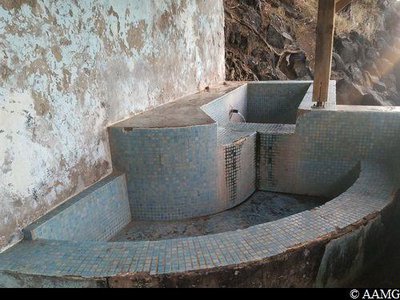
AAMG  History
Bain du Curé
A natural thermal spring located in Anse à Sable near the presbytery. In about 1845, one of the parish priests (curés) living in Bouillante turned it into a concrete pool, hence the name: Bain du Curé (Priest's Bath).
Today, many people drink the water for its iron-rich properties and its beneficial effects for skin and rheumatic diseases.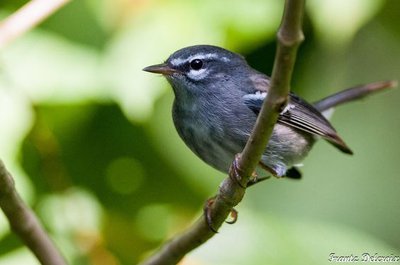
F. Delcroix  Fauna
FaunaPlumbeous warbler
The plumbeous warbler (Setophaga plumbea) is a small bird, 12 cm long. Adults have grey feathers, white markings above the eyes and 2 stripes along the wings.
They can be found in humid mountain forests, sometimes in dry brush forests and also in mangrove forests. They are quite common in Basse-Terre, but seldom seen in Grande-Terre. The species is endemic and widespread in Guadeloupe and Dominica.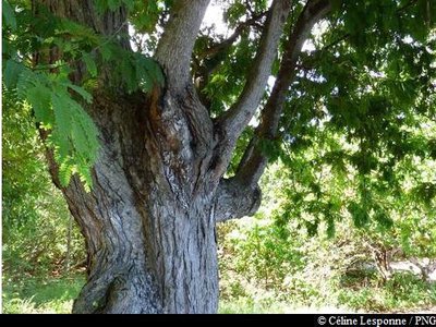
PNG FloraTamarind
Tamarind (Tamarindus indica) is a member of the Fabaceae family. Its fruit consists of brown, bean-shaped pods. Inside, the pulp is surrounded by seeds. The tangy taste of the flesh is delicious. The fruit is made locally into juice and jellies. It is also an excellent natural laxative.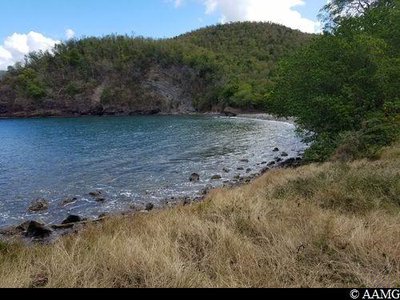
AAMG  Viewpoint
Anse Machette
In Anse Machette turtles lay their eggs, especially hawksbill sea turtles and green sea turtles.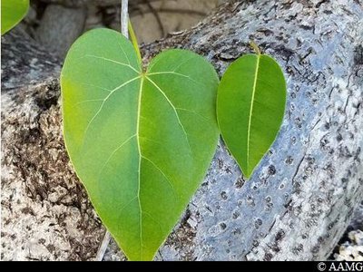
AAMG FloraManchineel tree
Be careful, the tree contains a toxic latex.
Not to be confused with the portia tree, a common coastal plant with heart-shaped leaves.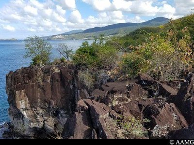
AAMG ViewpointPointe à Lézard
An old resistance and defence site, as can be seen by the remains of cannons from the artillery battery.
AAMG ViewpointAt the heart of Bouillante
Bouillante's bay has an original and attractive heart shape.
Description
Leave the car park and follow the tarmac road as far as the stone path which slopes down towards the right. Follow the path to the 1st intersection on the right.
The trail gradually continues deeper into the forest and crosses the Bois l'îlet gully twice.
Walk alongside the gully then turn right onto a steep slope towards Morne Machette. Go straight on until a crossroads, where you turn right.
Continue alongside a pipe and following the mountain-bike markings.
Start the long descent through the undergrowth towards Anse à Sable. At the bottom of the descent, turn right towards Pointe à Sel.
The path gradually rises alongside the cliff until it comes to a sharp bend to the left. Follow the path, always staying on the right and close to the coast. Begin the descent towards Anse Machette. Cross Anse Machette, then turn right to follow the coast.
When you arrive at Pointe à Lézard, continue along the coast as far as a grassy area, then turn right up the slope. Once you get to the forest path that is partially adapted to cars, turn right and follow the path to the starting point.
- Departure : "Falaise", car park, exercise trail
- Arrival : "Falaise", car park, exercise trail
- Towns crossed : Bouillante
Altimetric profile
Recommandations
Please note, there is a mistake in the markings, so turn right at the start.
---
Don't begin the hike after 3 pm because night falls quickly in the forest.
Watch out for the manchineel tree at Anse Machette.
In this natural setting, you should be particularly careful and alert, since Guadeloupe is subject to natural risks. It is vital to act in a responsible way, so that everyone can enjoy the hike!
Please note: unsupervised car parks.
Information desks

plage de Malendure, 97125 Bouillante
Access and parking
GPS starting point: Lat: 16,13947° N - Long: 61,77369° W.
---
On the RN2 road to Pointe-Noire, 2 km after the town of Bouillante, park on the left at the "Falaise" section, near the exercise trail close to the "Aux Epices" restaurant.
---
On the RN2 road to Pointe-Noire, 2 km after the town of Bouillante, park on the left at the "Falaise" section, near the exercise trail close to the "Aux Epices" restaurant.
Parking :
"Falaise", near the "Aux Zépices" restaurant.
Source
Rando Guadeloupehttps://www.randoguadeloupe.gp/
Report a problem or an error
If you have found an error on this page or if you have noticed any problems during your hike, please report them to us here: