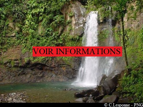
Third Carbet Waterfall
Capesterre-Belle-Eau
Third Carbet Waterfall
Medium
2h
3,7km
+197m
-197m
Return trip
PR (short hike network)
Embed this item to access it offline
This is quite an easy trail, but very muddy, despite a large number of pathways that have been laid down. The trail goes through a Mahogany plantation, planted in the 1950s and 60s.
Please note: a bylaw forbids access to the section after the platform and so to the 3rd Carbet Waterfall. This description is limited to the authorised sections, without the last part.
Please note: a bylaw forbids access to the section after the platform and so to the 3rd Carbet Waterfall. This description is limited to the authorised sections, without the last part.
6 points of interest
PNG  Information board
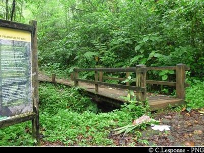
Footbridge + signs
You will come across trail resources all along the trail and a great many mahogany trees (Swietenia macrophylla). The species comes from South America. It was planted by the ONF from the 1950s onwards in a total surface area of over 4,000 hectares, and almost exclusively in Basse Terre in the thick rain forests.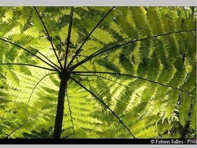
PNG  Flora
FloraTree fern
Tree ferns are fossil plants that are among the oldest plants growing on land. They can grow up to 15 m in height. Instead of a trunk, they have a stipe (like banana trees), with wide fronds, 2 to 3 metres wide, at the top. The young leaves are shaped like a bishop's crosier. The most common species in the hygrophile or rain forest is Cyathea muricata.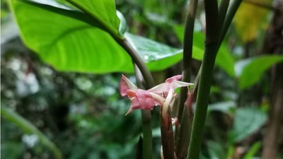
fleur d'Arouman - N.Liagre - PNG FloraSierran palm and Arouma
The Sierran palm is one of the few palm trees growing in the rain forests of Guadeloupe. The Ischnosiphon arouma is a beautiful plant with leaves that seem to hang from the end of the long, slender petioles. It is often used in wickerwork and regenerates easily by casting off its root stock.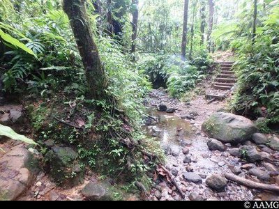
AAMG Information boardRiver to cross and panel
Be careful when you cross this small gully.
On the other side is a panel with information about animals living in the water.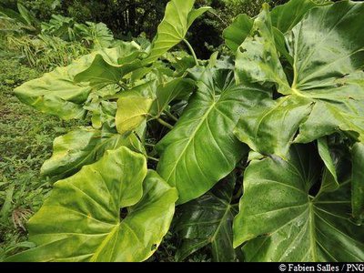
Siguine blanche - F.Salles - PNG FloraEpiphyte plants
They are one of the main features of the rain forest. They live on other plants, using them as a support but without acting as parasites. The most spectacular is probably the philodendron giganteum with its huge leaves (up to 80 cm long and 50 cm wide) growing on a stalk that can reach up to 1.5 m in length. Its scientific name is Philodendron giganteum.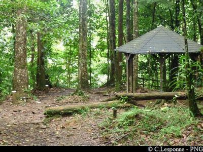
carbet, terminus de la randonnée - PNG FloraCrossroads and Candlewood
To the right are panels showing the way to the 2nd Carbet waterfall. Opposite, around a karbay without a table, are a wide range of trees identified with small panels. One of them is remarkable for its trunk with a fragrant white resin running from it. The resin is still used today as incense. The candlewood tree can grow up to 35 m high. It is one of the tallest trees in Guadeloupe. Scientific name is Dracyodes excelsa.
Description
The trail begins on a wide paved footpath, before you arrive at a small footbridge with two large information panels on either side. This is where the muddy part of the trail begins, but with many sections that have been adapted to hikers. A yellow sign shows there are 45 minutes to go.
After 35 minutes on this path (and crossing a gully two-thirds of the way along), you arrive at a fork towards the 2nd Waterfall and a disused karbay (with no table). From this point, the descent towards the ONF platform begins. The trail stops here (municipal bylaw).
You go back the same way.
After 35 minutes on this path (and crossing a gully two-thirds of the way along), you arrive at a fork towards the 2nd Waterfall and a disused karbay (with no table). From this point, the descent towards the ONF platform begins. The trail stops here (municipal bylaw).
You go back the same way.
- Departure : in Petit-Marquisat, above Routhiers, in Capesterre-Belle-Eau.
- Arrival : in Petit-Marquisat, above Routhiers, in Capesterre-Belle-Eau.
- Towns crossed : Capesterre-Belle-Eau
Altimetric profile
Recommandations
Take a good pair of shoes, water, a snack and a complete change of clothing.
In this natural setting, you should be particularly careful and alert, since Guadeloupe is subject to natural risks. It is vital to act in a responsible way, so that everyone can enjoy the hike!
Please note: unsupervised car park.
In this natural setting, you should be particularly careful and alert, since Guadeloupe is subject to natural risks. It is vital to act in a responsible way, so that everyone can enjoy the hike!
Please note: unsupervised car park.
Information desks
Reception area of Les Chutes du Carbet
terminus de la RD4 , route de l'Habituée, 97130 Capesterre-Belle-Eau
Opening hours :
- In low season (May 1st to June 30th, September 1st to October 31th) : daily from 7.00 am to 1.00 pm.
- In high season (November 1st to April 30th, July 1st to August 31th : daily from 7.00 am to 4.30 pm.
Services : reception centre, shop, toilets, parking, picnic area. The promontory of the reception area is accessible to people with reduced mobility.
In exchange for the services provided on the site, a financial contribution is requested to visitors (prices 06/2023 to 05/2024) :
- Adults : 5.45 € / pers.
- Children (- 12 years) : 3.30 € / pers.
- Families (2 adults + 2 children): 7.60 €
- Groups adults (from 8 pers.) : 3.80 € / pers.
- Groups children (from 8 pers.) : 1,65€ / pers.
- One-year access card : 8.75 € / pers.
GPS location : Lat: 16,04198 N - Lng: 61,63822 W.
Access and parking
GPS starting point: Lat: 16,04510° N - Long: 61,61565° W.
---
From Capesterre-Belle-Eau, follow the panels for "3ème Chute du Carbet". Take the D3 road towards Routhiers and Petit Marquisat, and continue to the end of the road.
NB: a municipal bylaw forbids visitors from going down to the waterfall (due to a rock slide).
---
From Capesterre-Belle-Eau, follow the panels for "3ème Chute du Carbet". Take the D3 road towards Routhiers and Petit Marquisat, and continue to the end of the road.
NB: a municipal bylaw forbids visitors from going down to the waterfall (due to a rock slide).
Parking :
Parking in the forest, at the end of the RD3 access road.
More information
Source
Rando Guadeloupehttps://www.randoguadeloupe.gp/
Report a problem or an error
If you have found an error on this page or if you have noticed any problems during your hike, please report them to us here: