Crest Trail via Bon Air
Bouillante
Crest Trail via Bon Air
Easy
1h30
2,3km
+537m
-8m
Cross
PR (short hike network)
Embed this item to access it offline
A wide, user-friendly trail, but also a favourite with hunters.
5 points of interest
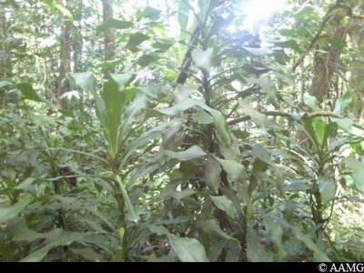
Sang Dragon - AAMG  Flora
Flora"Dragon's blood"
There are several kinds of "Dragon's blood" in Guadeloupe. This one is a member of the DRACAENA family. They can be green or green and yellowish white. They were imported from Africa to act as boundaries to plots of land or hedgerows. You will often see them on our trails. Sometimes you will spot them at the top of the mountains, which shows that these lands were farmed in the past.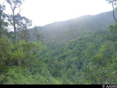
Vu sur le Morne Rézi - AAMG  Viewpoint
View over Morne Rézi
A viewpoint has been set up to offer hikers a spectacular view over the northern crest.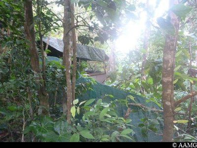
Campement de chasseurs - AAMG  History
Hunting camp
Hunting is deeply rooted in Guadeloupe culture, but game is rare and hunting is regulated. The hunting seasons starts on 14 July (hiking is strongly discouraged on that day) and ends on 31 December.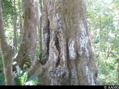
Gommier Blanc - AAMG FloraCandlewood
Candlewood, Dacryodes Excelsa, stands out with its long trunk (35 metres), up to 1.50 wide, and its grey colour. Unfortunately, cuts are often made in the bark to extract a sticky and fragrant sap (white resin). The sap is used to make incense, mainly during the carnival period, to smoke out evil spirits along the carnival route. Native Americans used the trunk to make boats (canoes or Kanaoua).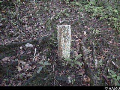
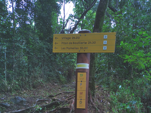
Borne forêt départementale - AAMG  Information board
Intersection with Barre de L'Ile
At this intersection is the Barre de l'Ile and Crête des Bois crossroads.
Description
The trail has clear markings (yellow), is clean and wide.
Stay on the main path (the widest one). You can't get lost as you make your way up before arriving at Barre de l'Ile.
You can then continue on other trails: towards the south-west and the "Village" trail or to the north-east towards the Piton de Bouillante.
Stay on the main path (the widest one). You can't get lost as you make your way up before arriving at Barre de l'Ile.
You can then continue on other trails: towards the south-west and the "Village" trail or to the north-east towards the Piton de Bouillante.
- Departure : the locality of "Bon Air" in Bouillante
- Arrival : Barre de l'Ile intersection
- Towns crossed : Bouillante
Altimetric profile
Recommandations
Take your time going upwards. Slowly but surely, as the saying goes. The uphill route will only challenge people who are not physically fit.
When it is raining, the path can be slippery.
NB: please note, unsupervised car park.
When it is raining, the path can be slippery.
NB: please note, unsupervised car park.
Information desks
plage de Malendure, 97125 Bouillante
Access and parking
GPS starting point: Lat : 16.13779°N - Long: 61.75133°W.
---
Arriving from Malendure (Bouillante), go past the Pigeon section. On the way up, turn left towards "Collège de Desmarais" and "Hopital". Go around the hospital, leaving it behind you and taking the little road descending steeply to the left. After the little bridge, the concrete road goes upwards. After 800 metres you will see the start panels for the trail to your left. Park at the edge of the road.
Parking :
There are a few parking spaces alongside the road near the start panels.
Source
Rando Guadeloupehttps://www.randoguadeloupe.gp/
Report a problem or an error
If you have found an error on this page or if you have noticed any problems during your hike, please report them to us here: