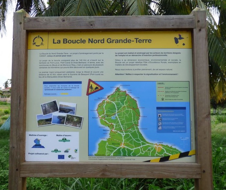
North of Grande Terre loop
An exceptional natural environment, a rich history, a little known heritage : a network of emblematic sites, over 3 different stages.
3 steps
45 points of interest
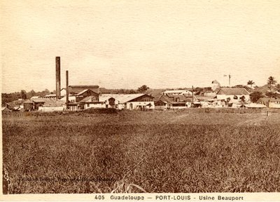
Ancienne sucrerie de Beauport - archives  History
Beauport factory
The Beauport factory, established in 1863 on the site of the Beauport sugar-works, over 70 years managed more than 8000 hectares in northern Grande-Terre, and fed a dynamic network of railway lines.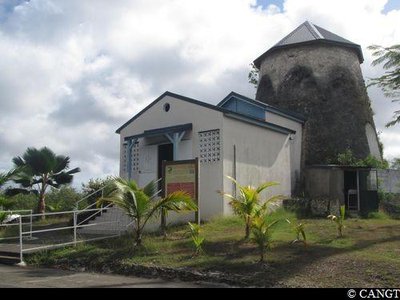
Chapelle de la Piéta - CANGT  Cultural and architectural heritage
Chapelle de la Piéta
200m north of the road, the Chapelle de la Piéta, can be found inside the mill of the Beauport residence.
Ancien dispensaire - PNG HistoryDispensary
An ancient dispensary, built by Ali Tur after the cyclone in 1928.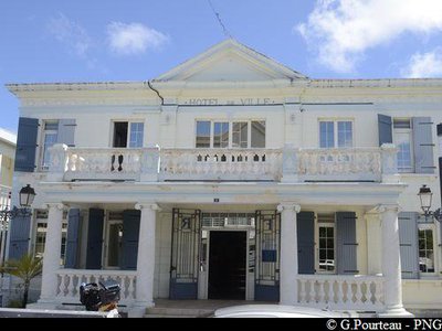
Mairie de Port-Louis - PNG HistoryPort-Louis Mairie
The Port-Louis Mairie (Town Hall), originally built on the coastline and destroyed in 1928, was rebuilt by Corbin during the 1930s.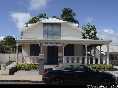
PNG Cultural and architectural heritage'Yang-Ting' mansion
The historic Yang-Ting mansion, restored by the Port-Louis Tourism Office.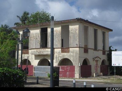
l'ancien Palais de Justice - CANGT HistoryPalais de Justice
The former Palais de Justice, built by Ali Tur in the early 1930s, on the site of the old Mairie (town hall).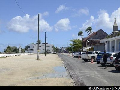
Boulevard principal - PNG HistoryMain Boulevard
Boulevard de Port-Louis, historical axis of the town since the eighteenth century.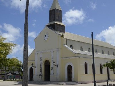
Eglise de Port-Louis - PNG Cultural and architectural heritageEglise de Port-Louis
The Church and its square, originally built in 1725, destroyed three times in the nineteenth century,but always rebuilt in the same place.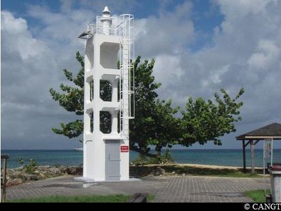
Phare de Port-Louis - CANGT Cultural and architectural heritageLighthouse of Port-Louis
The lighthouse, symbol of Port-Louis harbour.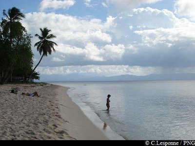
plage du Souffleur - PNG  Area of relaxation
Plage du Souffleur
The Plage du Souffleur, a historical area in Port-Louis and famous seaside centre in Guadeloupe.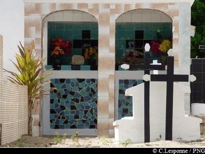
tombes - PNG Cultural and architectural heritageCimetière de Port-Louis
The Port-Louis cemetery with its variety of graves. The car-park at Port-Louis cemetery, heading northwards along the beach, joins on to that of the Conservatoire du Littoral 'Tras Kas Moustach'.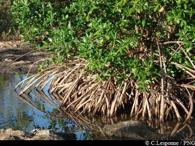
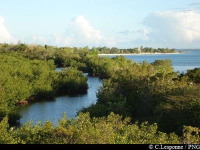
Palétuviers rouges - PNG  Pond
Pond'Chimen Kas Moustach'
Route of the Conservatoire du Littoral Tras Kas Moustach, to explore the Port-Louis marshes, joins the main axis at the Pointe des Mangles.
Beware : access not recommended to the boardwalk (currently damaged).Attachment
vue sur le Grand Cul-de-Sac Marin - PNG  Viewpoint
Pointe des Mangles
The Pointe des Mangles, where the sea and the waters of the marsh come together.
A fishing spot, but also a spiritual 'démaré' (rebirth) bathing area, not far from the ornithological hide.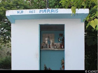
chapelle de la Pointe d'Antigues - CANGT Cultural and architectural heritageChapelle
The chapel of Notre Dame des Marais, or 'Chapèl Kilibwa', is one of a network of coastal chapels of the Côte sous le Vent in north Grande-Terre. Cultural and architectural heritage
Batterie Pointe d'Antigue
The buried remains of the old battery of Pointe d'Antigue, the advanced defence post of Port-Louis harbour.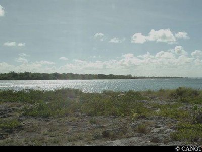
la Pointe d'Antigue - CANGT ViewpointPointe d’Antigue
Pointe d’Antigue or 'Gros Kay', a strategic rocky peak and unique viewpoint embracing the whole 'Gran V', the Grand Cul-de-Sac Marin.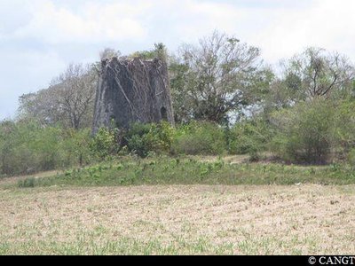
vestiges de l'Habitation Saint-Pierre - CANGT Cultural and architectural heritageSaint-Pierre
Secondary circuit around the Saint-Pierre residence, a large coastal housing area to the north of the marshes.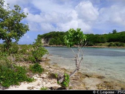
vue sur l'Anse Colas - PNG Area of relaxationAnse Colas
Anse Colas, a lagoon set in a rocky inlet is an area for meeting up and relaxing, at the border of the Anse-Bertrand and Port-Louis areas.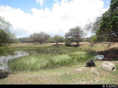
la Mare Indigo - CANGT PondLa Mare Indigo
La Mare Indigo, a stone's throw from the coast, is a witness to the human resonance between savanna, undergrowth and gardens.
(Mare Indigo can be seen 150m to the east of the main path)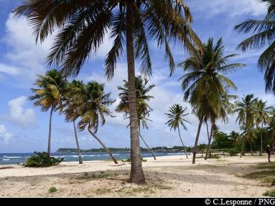
plage de la Chapelle - PNG Area of relaxationPlage de La Chapelle
The Plage de la Chapelle, lively and welcoming, was the historical start of the Anse in the eighteenth century (traces of the original religious foundation remain).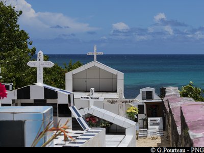
PNG Cultural and architectural heritageCimetières d’Anse-Bertrand
The two cemeteries in Anse-Bertrand are temporal markers of the coastal development of its past.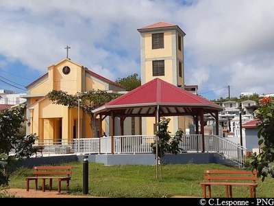
Eglise d'Anse-Bertrand et place aménagée - PNG Cultural and architectural heritageEglise d'Anse-Bertrand
The Church and its square, the heart of the town opening out to the 'cove at Bertrand'.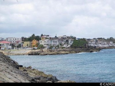
débarcadère d'Anse-Bertrand - CANGT HistoryDébarcadère d'Anse-Bertrand
The old water-tanks, or ways of storing water, and the former landing stage are relics of the maritime relations between the town, Port-Louis and Pointe-à-Pitre, still in use at the beginning of the twentieth century.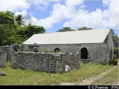
Ancienne prison - PNG Cultural and architectural heritageAncienne prison
The former prison, built on the eve of the abolition of slavery in the middle of the nineteenth century, is located on the Boulevard, in the historic fishermen's district.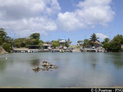
vue sur le port de pêche - PNG PondRavine Sable
Ravine Sable, anchor point of the cove's maritime culture, benefits from both its valuable wetlands and the rich birdlife, at the foot of the cliffs.
NB: ornithological observatory on the area (opened on October 2017 by the Anse-Bertrand Community and the National Park)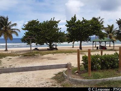
Plage de L'Anse Laborde - PNG Area of relaxationAnse Laborde
Anse Laborde, a renowned seaside cove, starting point of the northern cliffs.
It is bordered by the Pointe de la Petite Vigie, advanced sentinel of the urban stretch of water.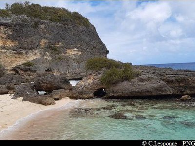
PNG  Geology
Trou de Man Louis
The only accessible beach with Anse Laborde on this side, barely visible from the cliffs (on the leeward side); the place for cliff fishing, including for 'bougo' (shellfish).
"Yaya", terrains en friche - PNG Cultural and architectural heritage'Yaya'
Yaya is a mystical space to the north of the village, where you may encounter spirits and other beings (mentioned in the story of Man Koko).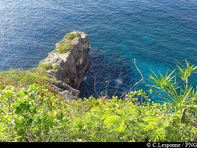
Pointe à Claude, territoire Caraïbe - PNG HistoryCaribbean site
The site of the village of the last Caribbeans in Guadeloupe, until the beginning of the twentieth century, in the heart of what was then known as the Caribbean Reserve.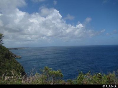
Pointe Montagnier - CANGT ViewpointPointe Montagnier
A rare viewpoint of this part of the cliffs, open to the Caribbean Sea and the Canal de la Guadeloupe.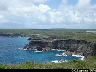
vue vers les falaises (sud) - PNG ViewpointPointe de la Grande Vigie
Pointe de la Grande Vigie, with its parking area and its double pathway to explore the site, going towards the point.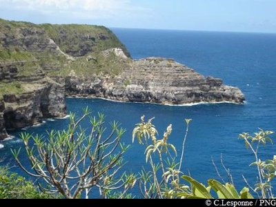
vue sur "La Tortue" depuis la Grande Vigie - PNG GeologyPetite Tortue
Pointe de la Petite Tortue, a cliff overhang shaped like the head of a turtle.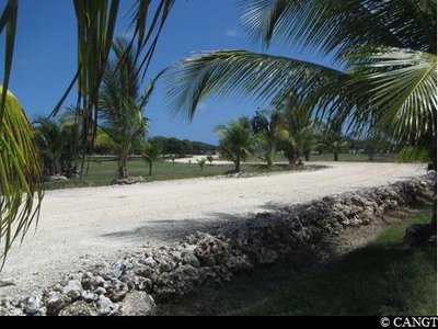
Savane Desrosières - CANGT PondSavane Desrosières
Savane Desrosières : vast space of the Caribbean Reserve, with its pools and grazing land, open to the never-ending movement of the Atlantic waves.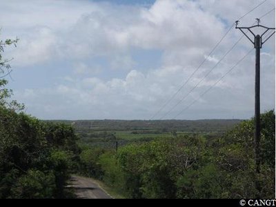
Couloir de Budan / St-Jacques - CANGT  Agricultural landscape
Couloir de Budan - St Jacques
The end of the Anse-Bertrand plateau, where we see a row of the more northerly sugar works of eighteenth century Guadeloupe, including those of Budan and St Jacques.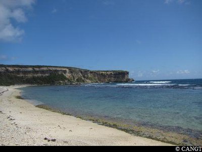
l'Anse Pistolet - CANGT GeologyAnse Pistolet
The Pointe de la Grande Vigie's only maritime access and the natural entrance to the south-west plain from the eighteenth century onwards, L'Anse Pistolet nestles between the cliffs occupied by the Amerindians millennia ago.
(The Anse is visible 400m to the north of the main road).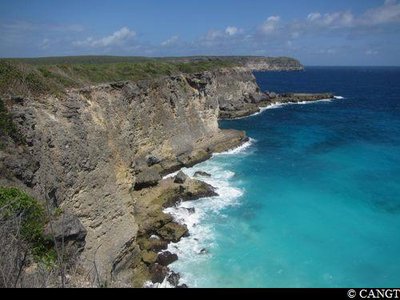
l'Anse à Tortues - CANGT ViewpointAnse à Tortues
A spectacular viewpoint nearer the edge of the cliffs, at the feet of which lies a cove of white sand, home to turtles when they come to lay their eggs.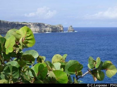
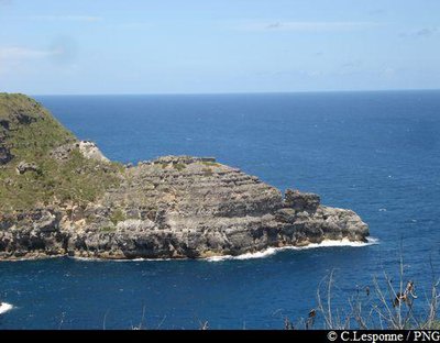
Le Piton (vue du sud-est) - PNG GeologyPointe du Piton
Pointe du Piton: witness to the tectonic movements at the start of the Grande-Terre region, and coastal erosion.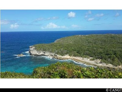
vue sur la Porte D'Enfer - CANGT GeologyOverlooking the Porte d'Enfer
At the start of Cadou: go west from the ridge, overlooking the lagoon of Porte d'Enfer, an open book of the geological history of Guadeloupe.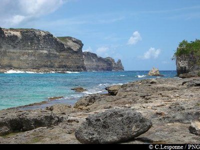
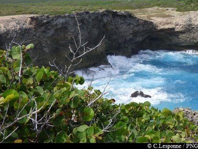
lagon de la Porte d'Enfer - PNG Area of relaxationPorte d'Enfer
The Porte d'Enfer lagoon, with its protected stretch of water, its landscaped picnic area, is the only single opening to the sea accessible, albeit difficult, on this coast.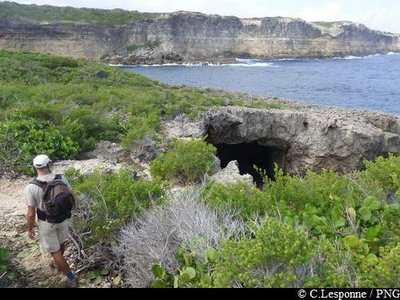
trou Madame Coco - PNG GeologyTrou a Man Koko
Madame Coco's blowhole is a mythical place linked to the legend of Madame Coco's pact with Lucifer.
trou du Souffleur (vue aérienne) - PNG GeologyTrou du Souffleur
The Pointe de la Tortue and the Trou du Souffleur, spectacular sea-water blowholes in the coastal rock.
Be careful, do not go near the edge !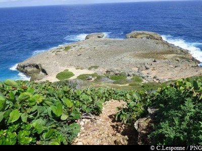
Pointe du Souffleur - PNG GeologyPointe du Souffleur
Pointe du Souffleur.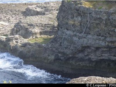
accès des pêcheurs aux falaises - PNG GeologyPointe "Tête à Boeuf"
Pointe "Tête à Boeuf" is a shore fishing place well known to the cliff fishermen ; it also serves as a seamark to fishermen out to sea off the coast.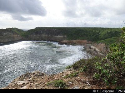
Anse à la Barque - PNG GeologyAnse à la Barque
L’Anse à la Barque: place-names and history. A network of trails, ponds and gullies.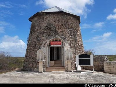
moulin de la Mahaudière - PNG  The Slave Route
Route de l'Esclave : La Mahaudière.
The oldest sources of information about this dwelling date back to 1732. At that time, it was not a sugar farm: around 1770, Etienne Douillard Mahaudière's property was more of a huge cotton estate, with a large number of 'cases' for the slaves but very few industrial buildings. At that time, there were many cotton estates in this part of Grande-Terre. The property grew progressively and turned to the production of sugar, until the Revolution, when it was sequestered. Two hundred people then worked on the 'Lahaut' residence, as it was known at the time. In 1828, 147 slaves were employed to maintain the 465 hectares of the property.
The owner was then Jean-Baptiste Douillard Mahaudière whose, name remains connected to a famous judicial matter.
In October 1840, he was taken to court for the abusive sequestration of his slave Lucile, a seamstress.
She was accused by her master of having poisoned his wife. Lucile was thrown into a cell measuring 5 square metres; it was only 1.20m high, so she could not stand upright. She was kept there for nearly two years in almost complete solitary confinement. Denounced to the law in an anonymous letter, Douillard Mahaudière had to answer for this crime before the Pointe-à-Pitre Assizes. The King's Prosecutor, himself a settler and owner in Guadeloupe, found himself torn between his role as magistrate and the interests of the community to which he belonged. Under pressure from the settlers, Douillard Mahaudière was declared not guilty and acquitted. The slave Lucile was sold.
In the years following the abolition of slavery, the house slowly fell into disrepair. At the end of the nineteenth century, the conversion of its facilities made it into a large steam-powered distillery. The activity continued on the site until the beginning of the 1950s.
Description
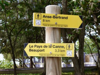
Hiking trail colour: yellow.
- First Stage :
From Port-Louis (Beauport) to Anse-Bertrand (Anse Laborde), passing through the coastline running alongside the bay of Grand Cul-de-Sac Marin.
- Second Stage :
In Anse-Bertrand : from Anse Laborde to La Porte d’Enfer, via La Grande Vigie, northern tip of the Guadeloupe Islands.
- Third Stage :
In Anse Bertrand : from La Porte d’Enfer to La Mahaudiere, following the trail of the cliffs.
Enjoy the hike !
---
For more information about the North Grande-Terre loop, check the following webpage : http://www.randoguadeloupe.gp/informations/partenariats/
- Departure : Port-Louis, "Beauport".
- Arrival : Anse-Bertrand, "Mahaudiere".
- Towns crossed : Port-Louis, Anse-Bertrand, and Petit-Canal
Altimetric profile
Recommandations
Please respect the signs and the environment !
Please follow specific recommendations for each stage.
Information desks

2 rue Gambetta, 97117 Port-Louis
Access and parking
RN6 road, between Port-Louis and Petit Canal : head towards the “lycee“ and the “usine” of Beauport. Follow the signs “Beauport, pays de la canne”, departure of the North Grande Terre loop.
Parking :
More information
Source
Report a problem or an error
If you have found an error on this page or if you have noticed any problems during your hike, please report them to us here: